Sikkim Darjeeling
ABOUT DARJEELING
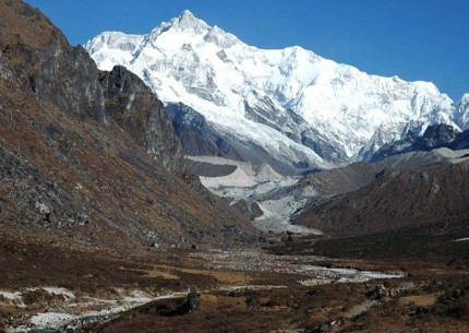
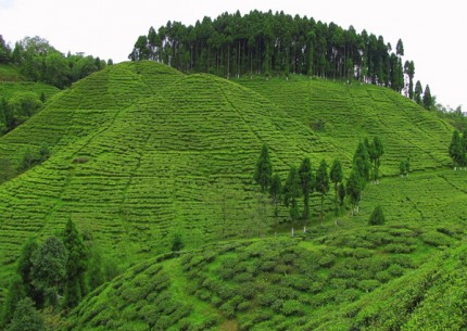
Darjeeling, "Land of the Celestial Thunderbolt," was given to the British as a "gift" from the once-independent kingdom of Sikkim. Lying in the Himalayan foothills and entirely surrounded by snowcapped vistas, Darjeeling soon became the favorite summer resort of the British Raj during the heyday of Calcutta -- when Mark Twain visited, he exclaimed it was "the one land that all men desire to see, and having seen once by even a glimpse would not give that glimpse for the shows of the rest of the world combined." Today, the incredible view of the world's third-highest mountain, Mount Kanchenjunga (8,220 m / 27,400 ft.), is undoubtedly Darjeeling's best-loved attraction, though the town has also acquired a global reputation for producing the "champagne of teas," and retains some of its haunting Gothic Victorian ambience. Most visitors are here to pick up a permit and get acclimatized for hikes through the mountainous state of Sikkim. It's worth noting that if you want a sleepy colonial hill-station environment, with splendid flower-filled walks, this is not it. Head instead for near by Kalimpong, which offers a number of charming old-world accommodations.
Two nights in Darjeeling should be more than enough, particularly if you're moving on to other Himalayan foothill towns. As with most hill stations, Darjeeling involves a considerable amount of climbing, and you'll do well to avoid the ugly mess of lower Darjeeling, which is typically congested, with suspicious odors, confusing back alleys, and a jumble of paths and stairways. Stick to The Mall and Chowrasta (crossroads) in upper Darjeeling, where life proceeds at a polite pace, and you can enjoy leisurely walks, stopping for a cup of tea or to browse shops stuffed full of trinkets and artifacts.
HISTORY
The success of the hill stations of Western India had induced the Government to do something for the citizens of Calcutta and the Bengal Presidency. An experimental station for ailing troops was opened at Cherrapunji in Assam, but it proved to be a wash-out-literally- as it turned out to be one of the wettest places in the world. But the government continued to look for an alternative place, and asked G.W.A.Lloyd to follow up the recommendation of J.W.Grant, the Commercial Resident at Malda, an enthusiastic explorer of the Himalayan foothills. The place Llyod and Grant inspected in 1829 was an old and deserted Gurkha military station 'Dorjeeling' or 'Darjeeling'.
The name Darjeeling is thought to be a derivation of 'Dorjeeling' meaning the place of the Dorjee, the majestic thunderbolt of the Lamaist religion. In fact, the famous Buddhist Monastery standing at the top of the Observatory hill was known by this name. The district was the part of the dominions of the Raja of Sikkim upto the beginning of the 18th century.
In 1817, the East India Company struggled with Himalayan States on behalf of Raja of Sikkim, The Raja of Sikkim restored the country between Mechi and the Tista rivers.This was the result of the Treaty of Titaliya of 1817.Ten years after the treaty,disputes on the Sikkim-Nepal frontiers arose and the then Governor General sent two Officers viz. Captain Lloyd and Mr. Grant. They recommended the present place of Darjeeling as a site for a sanatorium. The Governor General then deputed Captain Herbert, the Deputy Surveyor General to examine the country.The court of Directors approved the project. General Lloyd was directed to start negotiations with Raja of Sikkim and he succeeded in obtaining the execution of a deed grant by the Raja of Sikkim on 1st February, 1835.This deed of grant, which is commendably short, runs as follows:-
"The Governor-General having expressed his desire for the possession of the hills of Darjeeling on account of its cool climate, for the purpose of enabling the servants of his Government, suffering from sickness, to avail themselves of its advantages, I the Sikkim puttee Rajah out of friendship for the said Governor-General, hereby present Darjeeling to the East India, that is, all the land south of the Great Runjeet river, east of the Balasur, Kahail and Little Runjeet rivers, and west of the Rungpo and Mahanadi rivers." This was an unconditional cession of what was then a worthless uninhabited mountain; but in 1841 the government granted the Raja an allowance of Rs. 3,000 as compensation, and raised the grant to Rs. 6,000 in1846.
1839 was the most important year in the history of Darjeeling, the year the road which connected the hill station with the plains 'its life line' was built. Right from the start it had been pointed out by the planners. No road-No Darjeeling, and 1839 was the critical year when the decision was finally taken to go ahead with the plans.
The District was in the Rajshahi sub-division till October, 1905 and as a sequence of Bengal partition in 1905, the district was transferred to the Rajshahi division in March, 1912.The district was formerly a Non-Regulation district, that is, Acts and Regulations did not come into force in the district in line with rest of the country unless they were extended to it. Darjeeling had no representation in the Legislative Council. It was excluded and declared a backward tract. In 1935, the district was made partially excluded area by act.
The freedom movement in the district was much tempered by its moderate political ideology.One outstanding incident connected with the "terrorist movement" was the attempt on the life of Sir John Anderson, the Governor of Bengal, on May 8, 1934 by Bengali terrorists. The district with the rest of India attained independence as part of India in August 1947. According to the Constitution of India, the district no longer enjoys special privileges and all statutes, except the Bengal Tenancy act in certain of its particulars, apply to it.
However, the movement in the late 80's and early 90's has led to the formation of Darjeeling Gorkha Hill Council.This has resulted in more autonomy at the regional level with the participation of local people through their elected representatives by forming local council for management and development of the area.
TOURIST ATTRACTION
Tiger Hill
Situated at an altitude of 2590 meters (8482 ft.) and 13 kilometers from the town, this spot has earned international fame for the magnificent view of the sunrise over the "Kanchanjunga" and the great eastern Himalayan Mountains. Even Mount Everest, the world's highest peak, is visible from here. The hesitant rays of the early morning sun paint these peaks in pale gold.
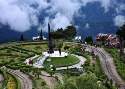
Batasia Loop and the War Memorial
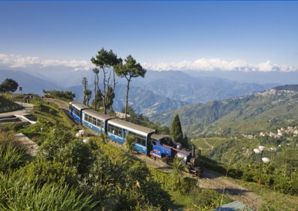
The Batasia loop situated almost 5 km away from the town is a gigantic railway loop where the Toy Train makes a 360 Degree turn. It was basically built to make it possible for the Toy Train to cut the deep ascend. Strategically located the Batasia Loop offers a panoramic view of the Kanchanjunga Range.A War Memorial constructed in the memory of the brave sons of the soil who laid down their lives in the different wars since the independence of the nation adds to its attraction. There is also a well furbished market where visitors can buy locally made purses, bags and other decorative items.
Ava Art Gallery
Situated about 4 km from the Market Square and on the National Highway, Ava.Art Gallery was established in 1965 by the Late. Bhopal Rao Sett and Ava Devi. It is the only Art Gallery of its kind in the Hills. A collection of 60 pieces of art work in water, oil and thread paintings are displayed in the Gallery. Visitors can travel on foot to get to the Gallery or simply hire a taxi. Entrance fees are not charged.
Chowrasta And Mall
Chowrasta, a wide promenade atop a ridge lined with shops and restaurants is taken to be the heart of the town. Here people gather to chat, spend time basking in the sun or just to snatch a moment of peace. The Brabourne Park is attached to the Chowrasta and now features a musical fountain. This place is an open place and free from vehicular movements from where one can watch the scenic beauty of the mountain range and take charm of walking at the Darjeeling Mall. Chowrasta is the central place of the Mall Road.
Rock Garden and Ganga Maya Park
Situated 10 km from town, Rock Garden and Ganga Maya Park has now developed into a very attractive picnic spot with natural water falls. The park offers boating facilities and is endowed with great scenic beauty. Ample eateries are available for visitors to indulge in local delicacies and one can even buy souvenirs. No fees are charged for taking photographs. Visitors are however, required to make arrangements for transportation. A two way travel arrangement is advisable.
Peace Pagoda
The Japanese Peace Pagoda was established by Nipponzan Myohoji, a Japanese Buddhist order. Situated on the slopes of the Jalapahar Hill the pagoda can be reached by foot or on taxi. The pagoda is the highest free structure in the town. It also showcases the four avatars of the Buddha.
Botanical Garden
It is the oldest Botanical Garden named as Lloyd Botanical Garden with varieties of flora and is famous for two living fossils. It is located just below the Eden Sanatorium(Saheed Durga Mall District Hospital) on an open slope covering an area of about 40 acres. Lloyd Botanical Garden is open seven days a week. There are no entrance fees. A camera, a small note book for a botany enthusiast and a couple of hours to spare, is a must.
Nightingale Park / Srubbery Park
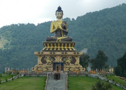
It is about 2-5 kms from Darjeeling Railway Station and walkable from the Chowrasta. It is a beautiful park with a package of cultural programmes performed daily during the tourist season and its opening time is 4.00 p.m. and closing time is 8.00 p.m. The park has recently been extensively re-developed, and now comprises of a giant Statue of Lord Shiva, a temple, and provisions for live-interactive entertainment. The best time to visit the park is in the evenings. Entrance fee is charged and nominal charges for photography may also be required to be made by the visitor.
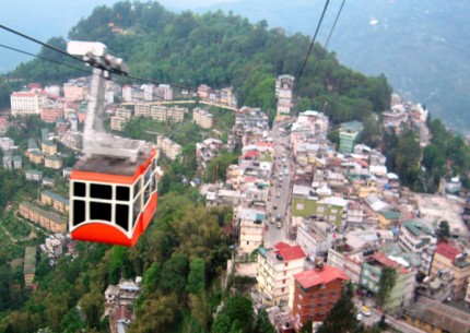
Darjeeling-Rangit Valley Passenger Cable Car
Darjeeling-Rangit Valley Passenger Cable Car is popularly known as the Ropeway. It is about 3 km north of the town and situated at what is known as the North Point. The Ropeway is India's oldest passenger ropeway and connects Darjeeling with Singla Bazaar at the bottom of the valley. The present ropeway has been extensively modernized and visitors can now safely travel over the clouds to witness the aerial view of the lush green tea gardens below.
Ghoom Monastery
Built in 1875 by Lama Sherab Gyatso, this ancient monastery is said to have been blessed by the renowned Tomo Geshe Rimpoche of Tibet. The specialty of this monastery is that it contains the statue of the 'Future Coming Buddha' known as Maitreye Buddha. The Monastery has also preserved some of the rare handwritten Buddhist manuscripts. You could visit the monastery on your return journey to Darjeeling from Tiger Hill.
Druk Thupten Sangag Choling Monastery(Dali Monastery)
This monastery is situated at Dali, about 4 kms away from Darjeeling town. This is one of the most famous monasteries belonging to the Kargyupa sect. The pioneer of this monastery was Thuksay Rimpoche, who died in 1983 and his incarnate is reported to have been born in 1986 at Ladakh. This monastery is the headquarters of Drukchen Rimpoche XII, the supreme head of the Kargyupa lineage.
Padmaja Naidu Himalayan Zoological Park
Established on the 14th of August, 1958, the zoo was dedicated to the memory of Padmaja Naidu, former Governor of West Bengal on the 21st November, 1975. Considered as one of the best zoos in the country, it is the only centre that breeds the tibetan wolf in captivity. Breeding programmes for the endangered red panda, snow leopard and the siberian tiger are also carried out at PNHZP. The zoo is open on all days except on Thursdays and other national holidays.
Dhirdham Temple
Dhirdham temple is modelled on the lines of the famous Pashupatinath temple of Kathmandu and was built in 1939. It is a minute's walk from the Darjeeling Railway Station.
Observatory Hill & Mahakal Temple
Also known to the locals as the "Holy Hill", it is just a few minutes walk from the Chowrasta and is situated on the highest ridge of the town. The Mahakal temple atop the hill is a revered place for the locals and visitors will be surprised to find a Hindu priest and a Buddhist monk sharing a common altar.
GETTING TO DARJEELING
By Air
Bagdogra Airport (96 kms from Darjeeling) has direct air connections to Calcutta, Delhi, Patna, Guwahati and other places of North-East India
By Rail
New Jalpaiguri (NJP) station at the base of Darjeeling Hill area has the direct railway connections to Calcutta, Delhi, Guwahati, Madras, Bombay, Bangalore, Bhubaneshwar, Tirupati, Trivandrum, Cochin etc. And from New Jalpaiguri to Darjeeling by toy train it takes 7 hours on a narrow gauge line.
By Road
Darjeeling is connected by road with Calcutta 651 kms, Gangtok 100 kms, Kalimpong 51 kms. Calcutta-Shiliguri have direct NSBTC Buses, daily.
ABOUT GANGTOK
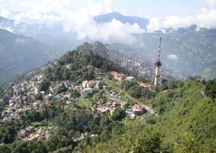
Gangtok is the capital of Sikkim. Gangtok lies on a ridge overlooking the Ranipool River. Its name means ‘High Hill’. It is situated at an altitude of 1547 meters and covers an area of 2.54 square km. The setting is spectacular with fine views of the Kangchendzonga range, but the town itself has long since lost its quaint charm. It is now rather dusty and uninspiring, and sprawls over the hillside. New and invariably ugly buildings dominate the urban landscape. All the main facilities including hotels, cafes, bazaar, bus stand and post office are along the main road from Darjeeling which ultimately merges with the old Hindustan-Tibet road. The best season to visit Gangtok is from mid of February to Mid of June and October to December. English, Nepali, Hindi and Tibetan are the various languages which are spoken in Gangtok.
GENERAL INFORMATION OF GANGTOK
Population - 75,000
Altitude - 1,547 meters
Area - 2.54 square km.
Best season - Mid Feb to Mid June and Oct to Dec.
Clothing - Summer light woolens and cotton, winter heavy woolens.
Language - English, Nepali, Hindi and Tibetan
TOURIST ATTRACTION
There are various places of sightseeing in Gangtok like Research Institute of Tibetology, Phurba Chorten, Ridge, Ganesh Tok, Hanuman Tok, Pinetum, Phurchachu Reshi Hot Springs, Tashi View Point, Changu Lake, Menmecho Lake, Do Drul Chorten.
Sikkim Research Institute of Tibetology
The Sikkim Research Institute of Tibetology is a premier institute in the world that was established to conduct research on the language and traditions of Tibet as well as the Mahayana sect of Buddhism. This institute houses a museum, a Tibetan library and a general reference centre. This research institute is situated at Deorali. The institute contains a rare collection of the Tibetan literature, manuscripts, paintings, coins, Thangkas and statues.
Phurba Chorten
Phurba Chorten is situated close to the Research Institute of Tibetology on a small hillock. This huge and towering religious monument is in the form of a stupa. The periphery of the Chorten is surrounded by 108 small prayer wheels with the mystic mantra ‘Om Mane Padme Hum’ in Tibetan inscribed on them. The Chorten was built by Late Trul Shik Rimpoche, who was the head of the Nyingama Order, and late Chogyal of Sikkim Tashi Namgyal. Inside the Chorten are placed a complete set of Kagyur holy books, relics, complete mantras and other religious objects.
Ganesh Tok and Hanuman Tok
Ganesh Tok is located on the hill adjoining the TV Tower. A small temple dedicated to the God Ganesh is situated on the hilltop at an altitude of 6500 feet. From the Ganesh Tok one can have a panoramic view of Gangtok and the Raj Bhawan Complex. The Pinetum garden is situated near the Ganesh Tok. This garden contains pine trees and a walk on the foothpath amongst the pine trees is refreshing. Hanuman Tok is situated about five kilometers uphill from White Hall on the Gangtok Nathula Highway. A temple dedicated to the God Hanuman is situated at an altitude of 7200 feet. On the way towards the temple, one can have a breathtaking views of Gangtok and the adjoining rolling hills.
The Ridge
The Ridge is a small stretch of plain and flat road above the town of Gangtok. It is just about fifteen minutes walk from the main market. The ridge is lined with plants and trees which when in bloom present a colorful picture. The Ridge has the White Hall and the Chief Minister’s official residence on one end and the beautifully designed Place Gate with a pagoda rooftop on the other end. A resting shed built on Tibetan architecture is also situated on the Ridge. Flower shows which attract tourists from all over the world are held just below the Ridge.
Tashi View Point
Tashi View Point is situated about six kilometers away from Gangtok on the North Sikkim Highway. This place offers an astounding view of the Kangchendzonga snowy range. The Phodong and the Labrang monasteries can also be seen on the opposite hill. A resting shed situated at Tashi View Point provides shelter to the tourists.
Phurchachu Reshi Hot Springs
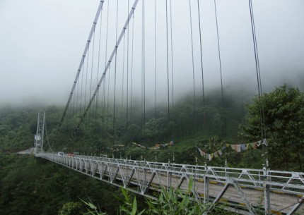
Phurchachu Reshi Hot Springs are located about 25 kms from Gyalshing near Reshi on the River Rangit. One has to walk about ten minutes from the highway across the River Rangit by a pedestrian bridge to reach the hot springs. The water of these springs has medicinal value as it is very rich in Sulphur that can cure various skin diseases.
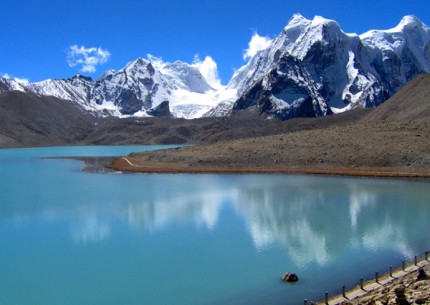
Changu Lake
The Changu lake is situated about 35 kilometers from Gangtok at an altitude of about 12000 feet on the Gangtok – Nathula highway. This lake is situated in the restricted area and hence an Inner Line Permit is required by Indians to visit this place. Foreign nationals are not permitted to visit this lake. Its cool water, flowers and the alpine vegetation harmonizes with the scenic beauty around. A small temple of Lord Siva is also constructed on the lakeside. Because of the high altitude, heavy woolens are required to be worn here throughout the year. A beautiful natural cave called the Tseten Tashi Cave is also located near the lake which is about three storey high.
Menmecho Lake
The Menmecho Lake is another beautiful lake that is located about twenty kilometers ahead of the Changu lake. This lake is very big in size, and lies cradled between the mountains below the Jelepla pass and is also the source of the Rangpochu river. The lake is known for its fish and a farm to cultivate these fish is also situated nearby.
Do-Drul Chorten
Do-Drul Chorten at Dotapu Chorten, Gangtok was built under the supervision of the late Most Venerable Trulshi Rinpoche after due preparations in 1945-46, in accordance with the prophecy made in 1944 by his Holiness the Dud-Zom Rinpoche. Placed inside the Chorten are a complete mandala set of Dorji Phurpa (Bajra Kilaya), one set of Kagyur holy Books, relics, complete 'zung' (mantras) and other religious objects. This chorten is considered to be one of the most important chorten of Sikkim. Around the chorten 108 Mani-Lhokor (Prayer Wheels) are installed. The Chorten is surrounded by Chorten Lhakhang, Guru Lhakhang, where two huge statues of Guru Rinpoche (Guru Padmasambahava) are installed, Drupda (Meditation Centre), Nyingma Shede (Institute of Nyingma Higher Studies) and many smaller monuments including the 'kudung' of the latter most venerable Trulshi Rinpoche. His Eminence Dodrup Chen Rinpoche of Sikkim has his seat at the Chorten Lhakhang and guides the disciples, including the inmates of the Drubda, in their search for higher knowledge and practice of the tenets of the Nyingma Order.
EXCURSIONS
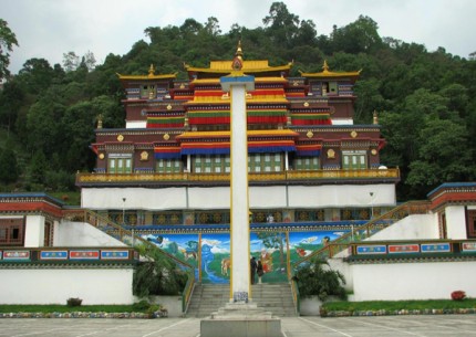
Rumtek Monastery
Rumtek Monastery is situated about 24 km. south west of Gangtok in one of the lower valleys. It is the headquarters of the Kagyupa (Red Hat) sect of Tibetan Lamaistic Buddhism. The 16th Gwalpa Karmapa took refuge in Sikkim after the Chinese invaded Tibet. He and his followers brought with them whatever statues, thangkas and scriptures they could and at the invitation of the Chogyal, the Karmapa settled in Rumtek and the lamasery was built. The original monastery built by the 4th Chogyal and destroyed by an earthquake, was rebuilt in the 1960s in the traditional styles as a faithful copy of the Kagyu headquarters in Chhofuk, Tibet and now houses Dharma Chakra Centre. The important chham (religious masked dance) of Rumtek is performed on the 10th day of 5th month of the Tibetan calendar, and presents 8 manifestations of the Guru Rimpoche. This is highly colourful and spectacular and draws many pilgrims and visitors.
Kabi Longstok
Kabi Longstok is situated about 17 kms away from Gangtok. At this place, the Tibetan chieftain, Khey Bumsar signed a blood brotherhood with the Lepcha shaman Te-Kung-Tek. The spot is marked by a stone amidst the shadows of a dense wooded area. The Statue of Unity erected near the Thakurbari Temple in Gangtok is in the memory of this event.
Chungthang
Chungthang is situated about 95 kms. away from Gangtok, enroute to Yumthang. This tiny hamlet of Chungthang lies at the confluence of the two rivers, the Lachen Chhu (which later evolves into the Teesta) and the Lachung Chhu. The main feature of this place is a footprint atop a rock which is said to be that of Guru Padmasambhava
GETTING TO GANGTOK
By Air
The nearest airport is situated at Bagdogra, about 124 kms. from Gangtok, and has daily Indian Airlines connections with Kolkata and Delhi.
By Rail
The nearest railway stations are at Siliguri (114 km) and New Jalpaiguri, which is about 125 kms. from Gangtok and well connected with all major cities of India.
By Road
Gangtok has only a road connection with the rest of India. Gangtok is connected with Darjeeling, Kalimpong and Siliguri by the National Highway 31.
ABOUT KALIMPONG
|
Kalimpong is the best hill station for the family holiday or a honeymoon trip. Kalimpong is the largest of the four sub-divisions of the district of Darjeeling in the Darjeeling Gorkha Hill Council, an autonomous body within the State of West Bengal. Kalimpong is a small sleepy hill resort and lies in Darjeeling District. With a population of about half a lakhs, it is ethnically and culturally similar to Darjeeling. Kalimpong lies between the plains of the Dooars and the hills of Darjeeling-Sikkim Himalayas. Nestling in the lush green mid ranges of the Himalayas, this hill station of "the Raj", has an incredible stunning backdrop of towering snow capped peaks and offers a quiet and relaxed holiday against the backdrop of Kanchenjunga. Kalimpong means the fort of the Kings minister (Kalim = Kings Minister, Pong = fort). And this name came got established when this area was under the Bhutanese, who occupied it in 1706. Before that Kalimpong was a part of Sikkim. Bhutan retained Kalimpong till 1865 after which it along with the Doors was ceded to British India. Due to its ideal location at an average of 1250 meters above mean sea level, there are mild weather conditions throughout the year. Kalimpong has a moderate climate ranging from between 15 to 25 Degree Celsius in Summers and 7 to 15 Degree Celsius in Winters. From spring getaways to getting wet in the summer monsoon rains, from watching the rice harvest in autumn to experiencing the joys of sharing a blanket in the winter chill, Kalimpong is fast emerging as the ultimate holiday destination in the Eastern Himalayas. English, Nepali, Hindi and Tibetan are the main languages which are spoken in Kalimpong. One important facet of Kalimpong as a holiday destination is it’s year-round salubrious climate. Whether in spring, summer, autumn or winter the visitors will find Kalimpong a pleasant and safe place to spend a holiday. The hub of all activity centres around the Chowrasta and the Bus Stand in the heart of the town which abounds in good as well as cheap hotels and restaurants. During the days yonder, it used to be the hub of trade activity of India with Tibet and the trade route used to be through Pedong, Rongli in Sikkim and then the pass of Jelepa on the Sikkim – Tibet border but Chinese invasion in 1962 put an end to all that. Area - 1,056.5 square kilometers HISTORY Kalimpong was once a part of the kingdom of Bhutan and the headquarters of a Bhutanese Governor. The word 'Kalim' means King's Minister and 'Pong' means the stronghold of the King's minister. It is also called 'Kalibong' or the black spur by the hill people. 'Kalipong' in local dialect stands for 'Kaulim' which is a fibrous plant which grows in abundance in this region. It is said that the local tribesmen or Lepcha used to organise field sports while not engaged in agricultural pursuits. IN 1865, after loosing out to an armed British intervention, Bhutan ceded the territory of Kalimpong to British India. After the Anglo-Bhutan War, it was merged with Darjeeling, and became a sub-division of Darjeeling in 1916, and developed as a hill station. It flourished as a wool trading centre with Tibet till 1950, when the Chinese took over Tibet. As Tea garden opened up in nearby Darjeeling people from Nepal migrated in search of a livelihood. Some spilled over to Kalimpong. The British missionaries came in during the late 1800’s and left a legacy of good schools, high educational standards, charitable institutions and architectural styles reminiscent of the English countryside. Not to mention their love for flowers and gardening. People from mainland India came in to settle in Kalimpong and brought with them their skills in entrepreneurship and trade. Over the years Kalimpong slowly developed into a trading center from which all trade to and from Tibet passed. This continued till the mid sixties when Tibet ceased to exist as an independent nation and the mule trains wound up. It continues to be part of Darjeeling District, and is now an attractive tourist and educational centre. CULTURE In Kalimpong, Buddhism rubs shoulders with Hinduism and Christianity. Gompas, churches, temples, monks and missionaries coexist in a jovial society. Kalimpong offers Buddhist monasteries, Hindu temples, Christian Churches, flowers, orchids and exotic flora, old colonial bungalows, scenic view points and the panorama of snows. This exotic town of beautiful people, mystical and enchanting, with a rare ethnic blend of hill people, has a tradition of hospitality from the days of the mule caravans of olden days. As a melting pot of such diverse and rich cultures of the people of Bhutan, Nepal, Sikkim, Tibet, mainland India, the British and the Lepchas (original inhabitants of the region), Kalimpong evolved its own unique blend of a way of life from cuisine, culture, etc. FlORA Kalimpong sub-division is more or less covered by forests and terraced agricultural land where rice, corn, millet and seasonal vegetables are grown. Herbs and spices like ginger, cardamom and turmeric are also grown as a cash crop by the villagers. From tropical foothills to the alpine regions, around 4000 flowering plant species including more than 400 species of orchids, trees, ferns, mosses, grasses and medicinal plants are represented in the region. Floriculture is another major economic activity in Kalimpong. There are various flower nurseries, many of world renown, producing plants for export and the home market. Cacti, Succulents, Orchids, colourful houseplants and bulbs in many varieties are some of the popular family of plants. Kalimpong flower nurseries present a permanent year-round flower show. TOURIST ATTRACTION The tourist attractions in Kalimpong are Thongsha Gompa, Zong Dog Palri Fo-Brang Monastery, Tharpa Choling Monastery, Nature Interpretation Centre, Mangal Dhaam, Colonial Bungalows, Dr. Graham's Homes Campus, Kalimpong Arts and Crafts centre, Dharmodaya Vihar, Kali Mandir, Gauri Pur House. There are some panoramic snow views of Kanchenjunga, Siniolchu, Paunhari, Lama Anden, Chola, Nathu La, Jalep La and Gymochen peaks. The best view points are Durpin Dara and Deolo View Point. Thongsha Gompa Tharpa Choling Monastery Zong Dog Palri Fo-Brang Monastery Nature Interpretation Centre Army Golf Club St. Teresa Church Flower, orchid and exotic flora nurseries Mangal Dhaam Dr. Graham's Homes Campus Deolo View Point Kalimpong Arts and Crafts centre Dharmodaya Vihar Durpin Dara Kali Mandir Gauri Pur House EXCURSIONS Lolegaon Samthar Plateau Pedong Samco Ropeway Teesta Valley GETTING TO KALIMPONG By Air By Rail By Road Note |
ABOUT LACHEN
The town of Lachen is located in the Indian state of Sikkim. This town is located in the northern part of Sikkim, and is one of the most beautiful places in the entire state. Lachen is a small town that is located at an altitude of around 8838 feet. It lies on the North Sikkim highway; hence access to Lachen is quite easy.
There are many interesting places in and around Lachen that you can visit during your trip to the place. Lachen is primarily famous as a sightseeing spot, with its many viewpoints that provides splendid shots of nearby mountains and greenery. You can also travel to Chopta Valley from Lachen, as this scenic destination is located quite near the place. This valley is a famous spot among tourists who love hiking and bird watching, and it is an important place that you should visit.
Green Lake is another famous tourist spot near Lachen that is open for tourist access. You can also take a trip to Kunchenjunga National Park, which is located near Lachen and has a wide variety of wildlife. Gurudongmar Lake is another important must visit destination that is also considered sacred by Hindus and Buddhists, but foreigners will not be allowed to visit this lake, which is near the Indo-China border.
TOURIST ATTRACTION
Yumthang Valley
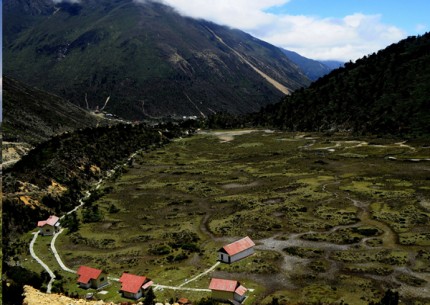
The Yumthang Valley is a grazing pasture near Lachen surrounded by Himalayan Mountains. It lies at an elevation of 3575 m above sea level and is situated at a distance of 150 km from the state capital, Gangtok. The popular Singba Rhododendron Sanctuary is also situated in this valley. It consists of over 24 species of rhododendrons, which is also the state flower. The tributary of River Teesta also flows past this valley. It experiences heavy snowfall between the months of December and March.
Lachung Monastery
The Lachung Monastery also known as Lachen Gompa is an old Buddhist monastery of Sikkim situated in the Lachen Valley of North Sikkim. This monastery lies at an altitude of 2750 m and also forms the base for the Green Lake trekking and mountaineering activities in Sikkim. It was built in 1806 and belongs to the Nyingmapa sect of Mahayana Buddhism. It has been reconstructed once in 1979. This monastery houses some religious beliefs of the Buddhist community along with the statue of Guru Padmasambhava or Guru Rinpochi. There is also a prayer wheel constructed at the entrance of this monastery to welcome tourists to the Handicraft and Handloom Centre under the rural tourist scheme. Several village festivities also form a part of this monastery.
Singba Rhododendron Sanctuary
The temple is situated about half way up the hill above the village. 5 Km from Kausani The first is a small conical structure, 2.5 to 3 meters high, dedicated to Bhairon. The main temple is close to this on the north, a squre, slated structure, with the door facing the south, and figures of rajas, etc., sculptured on the walls.The famous fair celebrated every year in October.
GETTING TO LACHEN
By Air
Flights can be taken to the nearest airport, which in this case lies in the town of Siliguri. This airport, also called as the Bagdogra Airport, is connected to all major Indian cities through a series of flights and many carriers.
By Rail
Lachen does not have a train station, and the nearest station is New Jalpaiguri, at a distance of 127 kms from Lachen. New Jalpaiguri has 3 train stations. They are Newjalpaiguri, Jalpaiguri and Jalpaiguri Road.
ABOUT LACHUNG
Lachung is a town located in the state of Sikkim. It falls under the north Sikkim district and is not very far from the China border. At an altitude of about 3,000 m above sea level, Lachung is located at the confluence of River Lachen and River Lachung, which are tributaries of the Teesta River. A forward base has been set up in this town by the Indian Army to guard and protect the borders.
The town of Lachung is located in the Indian state of Sikkim. This town is located in the northern part of the state in North Sikkim district, and it is located at an altitude of 9600 feet. Lachung is a tourist hotspot and a scenic destination that is located at the point where two tributaries Lachung and Lachen converge. These are the tributaries of the river Teesta. This town is frequented by tourists because of the many waterfalls that are located in the region. Snow capped mountains can also be seen near the region.
There are a few important places that you can also visit during your trip to Lachung. Lachung Gompa is one such destination which is a tourist hotspot. Also called as Lachung Monastery, this place attracts many pilgrims into its fold. This is a very old monastery that was built in the year 1880. There are many murals here that will delight history buffs, and the monastery also sports two wheels.
Mount Katao is a popular destination near Lachung that lies at a distance of thirty kilometers. This destination is only open for tourists in India. You can also visit the Shingba Rhododendron Sanctuary near Lachung, which is a popular destination among tourists
HISTORY
The term Lachung means ‘small mountain’. It is at a distance of about 125 km from Gangtok, the capital city of Sikkim. In the book ‘The Himalayan Journal’, British explorer and writer, Joseph Dalton Hooker, has defined this place as the ‘most picturesque village of Sikkim’.
Before 1950, when Tibet was not taken over, Lachung was a major trading post between Tibet and Sikkim. After it was closed down, the town continued to remain intact. The Indian Government opened it again and since then it has emerged as a major tourist hub in Sikkim.
PEOPLE AND CULTURE OF LACHUNG
People living in Lachung are commonly known as the Lachungpas. Lachung is mainly inhabited by Lepcha and Tibetan people. The most common languages spoken here include Lepcha, Bhutia and Nepali.
TOURIST ATTRACTION
The main attractions of Lachung tourism include the Lachung Monastery, which is also known as the Lachung Gompa, and the Yumthang Valley, which is about 25 km from the town.
The Lachung Monastery is a very old monastery, built in the year 1880. This place houses several murals, along with two wheels. Mount Katao, which is at a distance of about 30 km from this place, is also a popular tourist destination near Lachung. There are several Lachung holiday packages that can be availed to explore the destination.
The Yumthang Valley is a meadowland set amidst the Himalayan Mountains, at an altitude of about 3,575 m. This place is also famous for the Shingba Rhododendron Sanctuary, which has more than 24 species of rhododendron, the State Flower.
Lachung Monastery
The Lachung Monastery, at a height of 12,000 ft, was constructed in 1880. This monastery provides views of the countryside and the entire Lachung Valley. It is mainly a Nyingma Buddhist Gompa which lies at the confluence of the Lachung River and the Lachen River, which are tributaries of the Teesta River. The monastery is also famous for an annual mask dance festival.
Mt. Katao
Mt. Katao, near Lachung, is visited by many tourists, especially those interested in recreational activities like snowboarding, skiing, snow tubing and stone grinding.
Shingba Rhododendron Sanctuary
The Shingba Rhododendron Sanctuary is situated on the northern Lachung Valley, at an altitude ranging between 3,048 m and 4,575 m. The sanctuary covers an area of around 43 sq km. There are about 40 different species of rhododendron shrubs amidst the snow-covered mountains.
Some of the important trees in the sanctuary are primulas, poppies, gentians, potentillas, saxifrages and aconites. There are a few endangered animals inhabiting the sanctuary like the spotted lingsang or the tiger-civet. The ideal season to visit this sanctuary is between the months of November and mid-June.
Chungthang
Chungthang is situated in the North Sikkim District at the confluence of Lachen and Lachung Chu rivers. There is a forward base and a medical centre of the Indian army in this town.
GETTING TO LACHUNG
By Air
As Lachung is quite a small village nestled amidst the huge mountains it doesn’t have an independent airport. Bagdogra International Airport of West Bengal located about 128 kilometers from Lachung serves as the nearest airbase.
By Rail
Jalpaiguri Railway Station of West Bengal located near Siliguri about 139 kilometers from Lachung is the nearest train station from here. Jalpaiguri Railway Station has three sub stations namely: Jalpaiguri, Jalpaiguri Road and New Jalpaiguri.
By Road
Lachung is located about 59 km from Mangan, 98 km from Singtam,125 km from Gangtok, 141 km from Namchi, 147 km from Jorethang,166 km from Gezing, 176 km from Pelling and 212 km from Yuksam.
ABOUT PELLING
Pelling is a small town that is situated in the state of Sikkim in the West Sikkim region. The town is a laid back place and it attracts travelers from different parts of the country. Pelling is located near the foothills of Kanchenjunga and one can witness an outstanding view of the mountain from here. There are numerous scenic spots that one can visit in the area. The main attractions in the place are the monasteries that dot the countryside. Visiting these tranquil monasteries is a good way to spend time in the region. Some of the main places are Pemayansgtse Monastery and Sangachoeling Monastery. There are many sculptures and paintings that you can find in these places and they are not crowded. One can get a panoramic view from the Sangachoeling Monastery. If you are visiting during the month of January, you can see a dance called Cham in the Pemayansgtse Monastery.
The Sangay Waterfall is situated 10 kilometers from the town of Pelling and this is a good picnic spot. Another interesting place is the Kchehepalri Lake. The lake is present amidst dense forests and it is considered to be a holy place. It might also be worth checking the Rabdantsey Ruins.
TOURIST ATTRACTION
Darap Valley
On your way to other site seeing point you will pass through this valley which will fall in your right side. Darap village is promoted by tourism department for village tourism.
Rembi Waterfall
On the way at a distance of 11 KM from Pelling this water fall is just 2 KM before the Sewaro Rock garden. This one not so big water fall compared to other water falls in Sikkim.
Sewaro Rock Garden
Entry fee of Rs 10 is charged to enter this garden. From the main road you need to go down a bit to reach this garden constructed by the side of the river. You can touch the water here. This rock garden is 13 KM from Pelling and 30 minutes drive.After going 3 KM from Sewaro Rock garden you will reach one Y ( three road ) junction. Road towards your left side goes to Khechuperi wishing lake and the road towards right goes to Kangchenjunga water fall. From this point Kangchenjunga water fall is 8 KM and Khechuperi wishing lake is 9 KM.
Kahgchenjunga Waterfall
At a distance of 25 KM from Pelling it will take nearly one and half hour including the half hour stay at Sewaro Rock garden. You need to climb up little in steps to reach the foot of the water fall. This water fall is last but one point in your drive for local site seeing in Pelling. After this you will return to Y junction and go towards Khechopalri wiching Lake. Take care of your vehicle as there is no open parking space and stones may fall from heights.
Khechopalri Wishing Lake
This Lake is located at a distance of 25 KM from Pelling and 9 KM from the Y junction ( other road goes towards Kahgchenjunga water fall ). This scared lake surrounded by prayer flags is worshiped by both Hindus and Buddhist. From the parking area one can walk up to the Lake through a trail and by the side of a Monastery.
Khachoedpalri means mountain of blissful heaven. Lagand has it that this place was once a grazing ground abound with stinging nettle. Native Lepchas use the barks of nettle for multi-purpose requirements. One day a Lapcha couple as usual peeling if the bark of the nettle saw a pair of conchshells coming from the air and entering into the ground. After that the ground underneath shook violently and immense spring of water engulfed the entire ground which turned up into a huge lake. As pen nesal text this lake was recognized as the abode of Tshomen Gyalme or chief protective Nymph of Dharma as blessed by Goddess Tara. Native Buddhist believes that the shape of the lake is foot print blessing of Goddess Tara.
Pemayangtse Monastery
Located at a distance of 2 KM from Pelling, this is the one of the oldest and important Nyingma monastery in Sikkim. There is an entry fee of Rs 20 to visit this monastery. At hill top from this Monastery you can get good view of Kangchenjunga and other hill rages. You can also get a distance view of Rabdentse Ruins from here.
Visitors are allowed to visit inside and can climb up to 2nd and 3rd floor of the main building. Each floor has many traditional collections of Buddhist statues, traditional paintings, wooden masks and ritual texts. Some paintings are kept covered by cloths. At the top floor there is beautiful wooden replica of Zangdog Palri the celestial adobe of Guru Padmasambhava. This is the main attraction of the Monastery. This colorful and beautiful piece is kept inside a big glass box to preserve it. Note that photography is not allowed inside the main building.
Rabdentse Ruins
At a distance of 3 KM from Pelling and within 1 KM distance from Pemayangtse Monastery there is the ruins of the fort or palace of second capital of Sikkim. This place is well maintained and preserved by Archaeological survey of India.
From the parking place tourist have to walk nearly 1 KM in a well maintained jungle trail up to the ruins of the palace. The duration of walk will be for 20 to 30 minutes. If you are a seasoned walker then you will enjoy the trek but for aged senior visitors it may be little difficult. There is one alternate short road is under construction connecting this site bypassing the walking trail. You can get the view of main structure of Pemayangtse Monastery from here and in same way you can get a full view of ruins from the Pemayangtse Monastery.
GETTING TO PELLING
By Air
Nearest airport is the Bagdogra Airport that is situated outside the town of Bagdogra. The airport is located around 124 kilometers from the town of Pelling. There are scheduled commercial flights from places such as Chennai, Kolkata, Guwahati and Mumbai.
By Rail
The nearest railway station is situated in the town of Jalpaiguri. The station is connected to some cities across the country such as Chennai, New Delhi, Howrah, Alipur and Darjeeling.