North East India
ABOUT ARUNACHAL PRADESH
It is situated in the North-Eastern part of India with 83743 sq. kms area and has a long international border with Bhutan to the west (160 km), China to the north and north-east (1,080 km) and Myanmar to the east (440 km). It stretches from snow-capped mountains in the north to the plains of Brahmaputra valley in the south.
The visitor has a wide variety of options to pick from. There are places of worship and piligrimage such as Parasuramkund and 400 years old Tawang Monastery, or the sites of archeological excavations like Malinithan and Itanagar, the serene beauty of lakes such as Ganga lake or Sela lake or the numerous variations of scenic beauty of the snowclad silver mountain peaks and lush green meadows where thousands of species of flora and fauna prosper. In addition, the state provides abundant scope for angling, boating, rafting, trekking and hiking. Besides, there are a number of wild life sanctuaries and national parks where rare animals, birds and plants will fascinate the visitor.
Tawang War Memorial
Tawang War Memorial, a 40 foot high multi-hued memorial, has a structure constructed in stupa design. Dedicated to the martyrs of Sino-India War held in 1962, this memorial is nestled among beautiful peaks, which overlooks the Tawang-Chu valley. Popularly known as Namgyal Chorten, the memorial has names of 2,420 dead soldiers. The names of the soldiers are etched in gold on around 32 black granite plagues.
Tawang War Memorial comprises two memorial halls. One of the halls has the collection of personal articles of martyrs, while the other is used for sound and light shows, depicting their heroic deeds. The entire memorial was blessed by Dalai Lama.
Tawang Monastery
Tawang Monastery, also known as the Golden Namgyal Lhatse, is one of the largest lamaseries of Mahayana sects. This is the second oldest Monastery in the entire world after Lhasa. With a control over 17 Gompas in the region, this monastery is believed to be 400 years old.
This largest monastery in Asia stands erect at the base of a hill at a height of 3,000 metre above sea level. Dating back to 17th century, the monastery was constructed by Merak Lama Lodre Gyatso in accordance with the desires of the 5th Dalai Lama. It was believed by Monpas that Merek Lama was born at Kipti. He became a Lama at a very young age and commenced his career of meditation and praying.
Sela Pass
Sela Pass, with a height of 13,714 ft, is one of the most visited places in entire Arunachal Pradesh. Considered to be heaven on earth, the Sela Mountain Pass in winter is entirely covered with snow. Before reaching this pass, the travellers are welcomed by another lake, which is known as the Paradise Lake.
Gorichen Peak
Gorichen Peak, highest peak of Arunachal Pradesh, is located between Tawang and West Kameng districts. Bordering with China, this peak has a height of 22,500 feet. Located at a distance of 164 kilometre from Tawang Township, this peak is also known as Sa-Nga Phu, which literally means the Kingdom of Deity. According to Monpa tribe, this peak is considered to be one of the sacred peaks protecting them from all the evils.
BongBong Waterfall
BongBong Waterfall, also known as Nuranang Waterfall is located at a distance of 2 km from Jang, which is the administrative circle headquarter of Tawang district. 40 km from Tawang, the waterfall offers beautiful view of milky water falling from height of approximately 100 m. A visit to this waterfall is included in the itinerary of tourists travelling to Arunachal Pradesh.
The Handirafts Centre
The Handirafts Centre in Tawang is a major attraction for visitors. Created to promote the local small-scale industry, it is a good place to buy locally made handicrafts, woollen carpets, shawls etc. Also available are shoes, carved wooden works, utensils made of bamboo, handmade paper and Thanka painting.
The Itanagar Wildlife Sanctuary
The Itanagar Wildlife Sanctuary in Itanagar is a major tourist attraction for tourists interested in adventure activity. To the delight of biologists and tourists, expansive reserve features a various trees and foliage. One of the chief sources to maintain ecological balance, the sprawling sanctuary provides habitat to contrasting species such as macaque, capped langur, hoolock gibbon and slow loris.
Ganga lake
Ganga Lake, also known as Gyakar Sinyi, is one of the chief tourist spots of the city. The beautiful water body enthrals visitors with its peaceful environment, imposing surroundings of lush green mountains and crystal clear water.
Polo park
Polo Park is a beautiful botanical park located in Naharlagun region. The park has evolved as a major tourist attraction as it features a wide collection of flowers and orchids. Thickets of cane are the highlights of the park.
Ita Fort
Ita Fort is one of the renowned ancient marvels of the region, located in the middle of the capital complex in Papum Pare district. Constructed by Ahom rulers and identified as root of the city, the region is named after this fort. Spread over an area of 45 cubic metres, the historic fort gives the testimony of stone work.
Namdapha hornbill
Hornbill is a site situated within Namdapha, which is famous for spotting four hornbill species, namely white-throated brown hornbill and great hornbill. Besides hornbill, tourists can also spot white-tailed flycatchers, streaked wren-babblers, large scimitar babblers and pied falconets.
Deban
Deban, situated on the north bank of the Dihing River, is the main tourist attraction in Namdapha National Park. Serving as the headquarters of the forest department in Namdapha, Deban is the only site in the entire park where permanent accommodation can be found. It is a popular birdwatching spot, where tourists can see white-bellied Heron and Ibisbill. Additionally, primates like gibbons and capped langur can also be seen.
Moti Jheel
Moti Jheel, located in the buffer zone of Namdapha National Park, is a small natural pool. Located in Gibbon’s Land, the pool can be approached via the path, which runs through deciduous and semi-evergreen forests. While walking on the path leading to the pool, tourists can catch glimpse of birds like green cochoa and rufous-throated fulvetta. Tourists can also see gibbons, capped langur and Malayan giant squirrels.
Hanging Bridge
Hanging Bridge is situated on the Siang River and is one of the famous attractions of the destination. This 70 m long bridge is made of bamboo and cane and connects the destination with other hill tribes.
Ramakrishna Ashram
Ramakrishna Ashram, which is a famous sightseeing attraction among travellers, was founded by Sri Ramakrishna Paramhansa, Swami Vivekananda and Sharada Mata. This ashram is visited by devotees for meditation.
Kane Wildlife Sanctuary
Kane Wildlife Sanctuary is situated in the West Siang District, which in vicinity of Along. The sanctuary is spread over an area of 55 sq. km and has diverse flora and fauna. Some of the animal species that can be seen in this sanctuary include deer, elephant and small cats.
Travellers can easily reach Kane Wildlife Sanctuary by boarding buses or hiring taxis from Along. The best time to visit this sanctuary is between the months of October to April.
GETTING TO ARUNACHAL PRADESH
By Air
The Guwahati Airport is the best and the closest option for those who are arriving by air.
By Rail
Guwahati has the nearest railhead which is well connected with other city.
ABOUT ASSAM
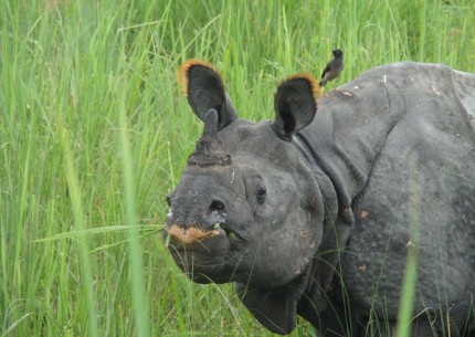
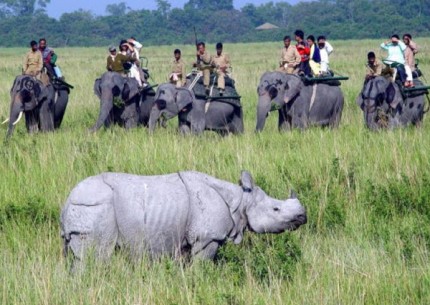
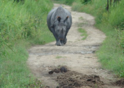
Assam is the central state in the North East Region of India and serves as the gateway to the rest of the Seven Sister States. The land of red river and blue hills, Assam is reflected peerlessness in the exquisite natural beauty, cultural richness and all round socio-economic scenario by its name. It is a region where nature herself has painted the vibrant landscape, hillocks, woods , brooks and streams, flora and fauna and above all the affectionate people. Crafted with much special care, the state of Assam India cast a spell on the travelers exploring the treasures of pleasure on Assam tourism. An abode of one horned rhino, blue rivers and red mountains, aromatic tea gardens make Tourism in Assam a special experience. Assam bears a testimony of rich cultural heritage through its temples, monuments, and torrential Brahmaputra River.
HISTORY
First mention of the state of Assam is found in the epics and the religious legends. The Aryans belonging to the priestly and warrior classes found their way into Assam in very early times. Various places mentioned in the epics, like Mahabharata etc. are now identified with sites in this state.
The first known ruler of Assam was Mahiranga Danava of Danava dynasty, who was succeeded in turn, in the direct line by Hatakasur, Sambarsur and Ratnasur. After them there was a chief named Ghatakasur, the ruler of the Kiratas. He made Progjyotishpur (the modern Guwahati) his capital, and settled numerous Brahmans at Kamakhya. Narakasur was killed by Lord Krishna of Dwaraka. Narakasur's successor, Bhagadatta, figured in the Mahabharata war leading a vast army against the Pandavas.
Sri Krishna frequently appears in Assam Mythology. Sri Krishna fought against king Bhismaka of Kundil (now Sadia) in his bid to marry Bhismaka's daughter Rukmini. Another king Banasura of Sonitpur (now Tezpur) fought against Sri Krishna, when Banasura's daughter Usha was secretly married to Anirudh, the grandson of Sri Krishna.
TOURIST ATTRACTION
Museum
Assam State Museum is 10 minutes walk from the Railway Station. The State Museum operated by the Assam government is located near Dighalipukhuri tank. The museum is extremely popular due to its amazing anthology of antiques right back to the prehistoric times. The collection boasts of some of the most authentic prehistoric sculptures, metal, ivory paintings, woodwork and costumes etc.
Opening hours: 10:00 - 17:00 hrs. during Summer 10:00 - 16:30 hrs. during Winter (Monday closed).
State Zoo cum Botanical Garden
Situated 5 Kms. from the Guwahati Railway Station. The zoo has a huge collection of reptiles, mammals and aves. The section for the reptiles has assorted as many as 358 reptiles of various kinds. The mammal section of the zoo has a total collection of 37 animals. The zoo has a huge collection of diverse kinds of birds that are placed in the ave section of the zoo. There are as many as 277 kinds of birds in the zoo
Opening hours: 07:00 hrs. - 17:00 hrs. in Summer 08:00 hrs. - 16:30 hrs. in Winter (Friday closed)
Srimanta Sankardeva Kalakshetra
The Srimanta Sankardeva kalakshetra has been set up as a grand exposition of the life and culture of the people of Assam. Named after the greatest Vaishnava saint and the greatest integrator of the Assamese society Srimanta Sankardeva, the Kalakshetra is a multi-Arts complex.
It houses a Central Museum where cultural objects and day-to-day articles used by different ethnic groups will be preserved and exhibited, an Open Air Theatre with 2000 capacity to hold folk festivals and to present traditional dance and drama of the State, an Artists' Village which offers the visitors and the residents an atmosphere of the village of Assam, the Sahitya Bhavan which is a library of rare books and manuscripts, the Lalit-Kala Bhavan which has sufficient space for exhibition, art and sculpture workshops, and a Heritage Park. The Kalakshetra has been chosen as the venue for many cultural activities.
Chandubi Lake
A natural lagoon and fine picnic spot which is 64 kms. from Guwahati. The lake and its surroundings is an ideal holiday resort with the added attraction of fishing and rowing.
The place is easily accessible by bus from Guwahati.The best season to visit is from November to April.
Sualkuchi
Assam produces three unique varieties of silks, the Golden Muga, the White Pat and the warm Eri. Silks grown all over the state find their way to Sualkuchi, 32 kms from Guwahati.
Sualkuchi is one of the world's largest weaving villages often called the Manchester of the East. The entire population here is engaged in weaving exquisite silf fabrics. A renowned centre of silk production, particularly known for Muga - the golden silk of Assam which is not produced anywhere else in the world.
Hajo
Located 32 kms. from Guwahati on the north bank of the Brahmaputra, it is a place where three religions meet - Hinduism, Islam and Buddhism.
It has a large number of temples, the chief among them being Hayagriva-Madhab Temple. There is a belief that this temple contains the relic of Lord Buddha, while a section of the Buddhist hold that Lord Buddha attained nirvana here. Large number of Bhutanese visit this temple every year during the winter season. There is a place of pilgrimage for Muslims here known as Poa-Mecca.
According to mythology, the Pandavas had taken shelter in this region during their agyatvas or the period in hiding. One can see the stone bowl used by Bhima during this agyatvas.
FESTIVALS
Bihu
Bihu is the most important festival of Assam. It is celebrated with joy and abundance by all Assamese people irrespective of caste, creed, religion, faith and belief. Bihu can be broadly divided into three categories: Bohag Bihu which augurs the wish for a good harvest because this is the time when farmers start sowing, Kaati Bihu which is observed to mark the cutting and binding of grains and Magh Bihu which marks the season of harvesting of grains.
Ambubachi Mela
Is the most important festival of Kamakhya temple of Guwahati and is held every year during monsoon (mid-June). It is a ritual of austerities celebrated with 'Tantric rites'. It is a common belief that the reigning diety, 'Kamakhya' , 'The Mother Shakti' goes through her annual cycle of menstruation during this period.
During Ambubashi the doors of the temple remain closed for three days. It is believed that the earth becomes impure for three days. During this time no farming work is undertaken. Daily worship and other religious performances are suspended during this period. After three days, the temple doors are reopened after the Goddess is bathed and other rituals performed. It is believed that the mother earth regains her purity now. This is purely a ritual of Tantric cult.
Ambubachi mela is held at the Kamakhya temple, after being closed for the afore-mentioned three days. On the fourth day only the devotees are allowed to enter inside the temple for worship. Thousands of devotees from all over India visit this mela.
Me-Dum-Me-Phi
The most important Ahom festival which deserves mention is the Me-Dum-Me-Phi, i.e., the ancestor worship festival which is observed by the whole Ahom community. This is performed annually on the 31st of January at some common venue. This in a way helps to develop social contacts and community feelings among the Ahoms. Colourful processions with devotees in traditional finery are also taken out on the occasion.
Jonbeel Mela
This spectacular fair(mela) is held every year during winter at Jonbeel of Jagiroad, a lesser known township only 32 kms from Guwahati. A few days before the mela, tribes like the Tiwas, Karbis, Khasis, Jaintias from the Meghalaya hills come down with their various products for this mela. On the occasion of the 'mela' a big bazar is held here where these tribes exchange thier products with local people in barter system which is very rare in a civilized modern society.
Before the 'mela' they perform fire worship or agni puja for the well being of mankind. It is to be noted that during this mela the 'govaraja' or the king of the Tiwa trbe along with his courtiers visit this mela and collect taxes from his subjects. The significant point of this mela is its theme of harmony and brotherhood amongst various tribes and communities. During the 'mela' these communities perform their traditional dances and music to celebrate the mela in a befitting manner.
Baishagu
Famous for its myriad colours and merriment, 'Baishagu' is generally celebrated by the Bodo Kacharis during mid April. It is the most cherished festival of the Bodo tribe. The Bodos also celebrate it as a springtime festival at the advent of the new year.
The first day begins with worship of the cow. The next day which synchronises with the first day of the month of 'Bohag' of the Assamese almanac, the actual merriment begins with the young people of each household reverentialy bowing down to their parents and elders. The supreme deity 'Bathou' or Lord Shiva is worshipped during the festival by offering chicken and rice beer. In the Baishagu dance there is no age or sex bar, all are welcome to join in. The traditional musical instruments that are used in this dance festival are 'Khum' (drum), 'Jotha' (Manjari), 'Khawbang' (Taal), 'Gogona' (Mouth-organ) and 'Siphung' (Flute) etc. It is also customary at the time of closure of the Baishagu festival to offer community prayers at a particular place called 'Garjasali'.
Bohaggiyo Bishu
This is the most fascinating spring festival of the Deoris of Assam, one of the four divisions of the Chutiyas, who are believed to have been members of the great Boro race. The term 'Bishu' might have originated from the Chutiya word 'Bishu'. 'Bi' means extreme and 'Su' means 'rejoicing' like other Springtime tribal festivals.
Bohaggiyo Bishu is also observed during mid-April at a stretch for seven days withunrestricted joy and merrymaking. It is to be observed that the Deoris Bishu do not always fall on the Sankranti Day. The Bishu must be preceded by a 'Than puja' and evidently it must start on a Wednesday. There is much socio-religious significance and arrangements to be made before the puja. Once in every four years a white buffalo is sacrificed which is considered a substitute for the traditional human sacrifice. The Deodhani dance is the most important and significant part of the festival. Husori or carol song party is the main attraction.
GETTING TO ASSAM
By Air
The Lokapriya Gopinath Bordoloi International Airport of Guwahati is well connected by air to most of the metros in the country. There are regular flights to Guwahati running all year long on daily basis.
By Rail
A convenient Indian Railways network runs throughout the state connecting major Indian cities with Assam.
By Road
Guwahati, the largest city in Northeast India, is the hub of the road network to the north eastern region. A good network of National.
ABOUT MANIPUR
Manipur is a land of jewels. Its rich culture excels in every aspects as in martial arts, dance, theater and sculpture. The charm of the place is the greenery with the moderate climate making it a tourists' heaven. The beautiful and seasonal Shirui Lily at Ukhrul, Sangai (Brow antlered deer) and the floating islands at Loktak Lake are few of the rare things found in Manipur. Polo, which can be called a royal game, also originated from Manipur.
Imphal is mainly inhabited by the Meitei with a large migrant population from Bihar, UP, Rajasthan, West Bengal, Punjab, Tamil Nadu, Kerala, etc. and it is just 7 km from the airport of Manipur. The district is divided into East and West and the recently constructed sports complex . Most of the imported goods are sold here at its Paona Bazar, Gam-bir Sing Shopping Complex, Ningthibi Collections and Leima Plaza.
TOURIST ATTRACTION
Shree Govindajee Temple
Temple with gold domes, a paved court and a large, raised congregation hall. The deity in the center has other idols of Radha Govinda, Balaram and Krishna and Jagannath, Balabhadra and Subhadra on either side of it.
Keibul Lamjao National Park
It is 48 km away from Imphal is an abode of, rare and endangered species of Brow Antlered deer. This ecosystem is home to 17 rare species of mammals. It is the only floating national park of the world.
Loktak Lake
Loktak Lake is a freshwater lake, floating islands popularly known as Phumdi which is made out of the tangle of watery weeds and other plants. With a nominal fee, people can hire small boats and see the fascinating way of life on these floating islands.
Churachandpur
Churachandpur is the second largest town in Manipur, business centre in the Khuga Valley. The main attraction of the district is the Khuga Dam, which is some 7 km south of the proper town.
War Cemeteries
Commemorating the memories of the British and Indian soldiers who died during the Second World War, these cemeteries are managed by the Commonwealth War Graves Commission. Serene and well maintained, the graves carry small stone markers and bronze plaques.
Khonghampat Orchidarium
7 km from Imphal, on National Highway 39 is the Central Orchidarium, which covers 200 acres and houses over 110 rare varieties of orchids, which include almost a dozen endemic species. The peak blooming season is March – April.
Manipur Zoological Gardens
6 km to the west of Imphal, at the foot of the pine growing hillocks at Iroisemba on the Imphal-Kangchup Road are the Zoological Gardens.
Moirang
45 km from Imphal, the town is one of the main centres of early Meitei folk culture with the ancient temple of the pre-Hindu deity Lord Thangjing, situated here. In the month of May, men and women, dressed in colourful traditional costumes, sing and dance in honour of the Lord at the Moirang "Lai Haraoba" which is a ritual dance festival held each year.
Loktak Lake And Sendra Island
48 km from Imphal, lies the largest fresh water lake in the North East India, the Loktak Lake, a veritable miniature inland sea. Visitors get a bird's eye view of life on the Lake-small islands that are actually floating weed on which live the Lake people, the shimmering blue waters of the Lake, labyrinthine boat routes and colourful water plants. The Sendra Tourist Home with an attached cafeteria in the middle of the lake is an ideal tourist spot.
Kaina
It is a hillock about 921 metres above sea level and a sacred place of the Manipuri Hindus. So goes the story that one night, Shri Govindajee appeared in the dream of his devotee, Shri Jai Singh Maharaja and asked the saintly king to install in a temple, an image of Shri Govindajee. It was to be carved out of a jack fruit tree, which was then growing at Kaina. The scenery in this place is charming and the hill shrubs and natural surroundings give the place a religious atmosphere. It is only 29 km from Imphal.
Khongjom War Memorial
36 km on the Indo-Burmese road, a war broke out between Manipur and British India in 1891. It is here that Major General Paona Brajabashi, one of the great warriors of Manipur proved his valor against the superior force of the invading British Army in 1891. A War Memorial has been constructed on the top of the Kheba Hill. 23 April is celebrated as Khongjom Day every year and is a state holiday.
Tengnoupal
69 km from Imphal. The highest point on the Indo-Burmese Road, from here, you can have a full view of the valley of Burma.
Ukhrul
83 km to the east of Imphal, this district headquarters of Manipur East is the highest hill station of the state. A centre of the colourful warrior tribe. Tangkhul Nagas, it is well developed and famous for its peculiar type of land-lily, the Shirui, grown in the Shirui hills. Shirui Hills and Khangkhui. Lime Caves are interesting places for excursions.
Manipur State Museum
The interesting museum near the Polo Ground in the heart of Imphal has a fairly good display of Manipur's Tribal heritage and a collection of portraits of Manipur's former rulers.
Maibam Lotpa Ching
It is a hillock about 16 km from Imphal on Tiddim Road. It is a thrilling spot where a fierce battle took place between the British and the Japanese force in World War II and regarded as a holy place. There is also a monument in memory of the Japanese Martyrs who sacrificed their lives in this fierce battle.
Willong Khullen & Yangkhullen
Willong Khullen is a village located some 37 km from National Highway 39 on the Maram-Peren Road. It is home to a stone erection very similar to Stonehenge. Some of the tallest stones are seven meters tall and one meter thick. The village of Yangkhullen is built on a steep slope on the hills.
Leimaram Waterfall
A popular tourist and picnic spot in Sadu Chiru known as Leimram waterfall 27 km from Imphal, in the Sadar hill area, Senapati district. Hundreds of tourist flocks to this place to enjoy the view of this waterfall and the natural beauty surrounding it.
GETTING TO MANIPUR
By Air
The nearest airport is Imphal. Imphal airport is the center point of reaching into the state as it is linked with rest of the country by air.
By Rail
Manipur is not well connected with other parts of country via railway network. The nearest railway station is Silchar in Assam. Apart from it situated at the adge of north east part of Nagaland, Dimapur is another nearby railway station to reach Manipur.
ABOUT MEGHALAYA
Meghalaya means "Abode of Clouds" is one of the seven Northeastern states of India. Meghalaya, of Scottish scenery and Indian charm is a beautiful state nestled amid Assam and Bangladesh. The Cherrapunji belt receives the highest rainfall in the world. Home to an extraordinary diversity of peoples, the Khasi, Jantia and Garo tribes, Meghalaya is one of the most picturesque states of India, which serves as an ideal gateway for people in search of beauty and tranquility. The panoramic landscapes, foggy hills, cascading waterfalls, serpentine rivers, and terraced slopes soothe the minds of weary travellers. Meghalaya is blessed with rich wildlife. The dense forests of Meghalaya are inhabited by many rare species of birds and animal including elephants, Tigers, Golden Cats, Binturongs, Slow Loris, Monkeys and birds like Hornbills, Partridges, Teals, Snipes and Quails.
It comprises of erstwhile Khasi Jaintia hills and Garo hills districts of Assam. Most of the terrain is hilly and experiences heavy rainfall during monsoons. Meghalaya is home to three major tribal population.
1. Khasi Hills
2. Jaintia Hills
3. Garo Hills
Khasi Hills
Khasi Hills is perhaps best known for Sohra (Cherrapunjee), geographically famous for being the wettest place on earth and also Shillong, one of the most beautiful hill stations in India. Infact the entire Khasi Hills region that forms the central part of Meghalaya is richly endowed with natural beauty. Everywhere you go, you will never cease to be mystified by the spectacular charm the state offers.
Shillong
The capital city of the State. Located in undulating pine covered hills, the city has a milder climate 103 Km from Guwahati.
Smit
Just 17 Kms South of Shillong is the traditional seat of Khasi culture. The Nongkrem dance, is performed in Smit during November.
Mawphlang
One of the most remarkable features of the Khasi Hills are the sacred forests, which have been preserved by traditional religious sanction
Sohra (Cherrapunjee)
Sohra, previously known as Cherrapunjee. It is credited as being the second wettest place on Earth. However, nearby Mawsynram currently holds that record. Though, it still holds the world record for the most rainfall in July 1861.
Laitkynsew
15 Kms further from Sohra (Cherrapunjee) there is a holiday resort run by a private party.
Mawsynram
Mawsynram is 56 kilometres from Shillong. Reportedly the wettest place on Earth, Mawsynram receives an average annual rainfall of 11,872 mm (about 39 feet).
Mawlynnong Village
Mawlynnong Village has earned the distinction of being the cleanest village in India. It is situated 90 kms. from Shillong.
Umiam Lake
More popularly known as Barapani, this is the biggest artificial lake in the State.
Lum Sohpetbneng
The navel of Heaven, is a place of pilgrimage for the Khasis of indigenous religion. Located on top of a hill.
Diengiei Peak
Located to the west of the Shillong plateau, Diengiei Peak is just two hundred feet lower than Shillong peak. The peak presents a spectacular view of green mountainous hills. The captivating hills are dotted with tiny shining villages.
Dwarksuid
An enigmatically beautiful pool with wide, rocky sand banks located on a stream alongside the Umroi-Bhoilymbong Road is known as Dwarksuid or Devil's doorway.
Mairang
Kyllang rock lies 78 km from Shillong. According to geologists, this rock is about several million years old.
Jakrem
Jakrem located about 64 km from Shillong on the Shillong-Mawkyrwat road, is famous for its hot water springs of sulphur water which is believed to have curative medicinal properties.
Mawkyrwat
35 kms from Nongstoin, Mawkyrwat presents panoramic landscape. A view point has been constructed on top of Mawranglang.
Mawthadraishan
Mawthadraishan peak, it is about 70 kms from Shillong on the Nongstoin road.
Nongkhnum Island
Nongkhnum Island is the biggest river island in Meghalaya and the second biggest river island in Asia, after Majuli Island in Assam.
Ranikor
On the banks of river Jadukata close to Bangladesh. Ranikor is a beautiful place. This area is famous for abundance of mahseer.
Jaintia Hills
Land of Myths and LegendsThe Jaintia Hills in the State of Meghalaya is bounded on the North and East by the State of Assam. On the South by Bangladesh and on the
West by East Khasi Hills District. The total area is 3,819 sq.kms. having a population of 2,95,692 (2001 Census). A land of undulating hills rich in mineral deposits. The natural vegetation changes according to the topography of the land kingdom of Jaintiapur now in present day Bangladesh.
Jowai
64 kms. from Shillong is the administrative headquarters of Jaintia Hills as well as the commercial centre. It is situated along side the Myntdu river which encircles two thirds of this over expanding township.
Nartiang
The Village of Nartiang is significant for its Summer Palace of the Jaintia King whose Capital was Jaintiapur. It is two kilometres from the Nartiang market.
Nartiang Monoliths
Monoliths exist the biggest collection of monoliths or Megalithic stones in one single area is to be found north of the Nartiang market.
Durga Temple at Nartiang
Adjacent to the ruins of the Summer Palace of the Jaintia King in front of the arched gateway of red bricks stands the Durga Temple.
Khim Moo Sniang
This locality derives its name from an embedded rock in the shape of a pig. The literal translation from 'Moo' is stone and 'Sniang' refers to pig. A stone deity venerated by the Jaintias for its protective power.
Thadlaskein Lake
It is a man made lake at Thadlaskein fed by a Perennial spring. According to tradition, one Chieftain Sajar Nangli had an irreconcilable difference with the King of Jaintiapur. Not wanting to be blamed for an inevitable bloodbath he decided to flee from the Kingdom with his followers. Before his departure, however, they dug the present day lake with the ends of bows as a memorial. The lake is revered by the people of Raid Mukhla who continue to offer sacrifices near the Lake. A popular picnic spot for locals.
Umhang Lake
This lake at Wataw (Bataw) village overlooking the plains of Bangladesh is flanked on either side by lush green forests.
Kiang Nongbah Monument
Kiang Nongbah, a Jaintia patriot during British rule who died as a martyr for the cause of Indian liberation from British rule.
Syntu Ksiar
Syntu Ksiar meaning Flower of Gold is a vast stretch of the river bank of Myntdu river where people usually go for picnics and angling.
Stone Bridge at Thlumuwi
16 kms. from Jowai on the Jowai Muktapur road to Dawki lies Thlu Muwi. This stone bridge built by U Mar Phalyngki and U Luh Lamare for the Jaintia King.
Lawmusiang
The largest Jaintia market as well as the commercial centre of Jaintia Hills. Jaintia Hills is famous for its spices.
Ruparsor Bathing Ghat
This bathing pool is hewn out of granite. The water which comes into the pool is through the curved trunk of an elephant fed by the Rupasor stream.
U Lum Sunaraja
It is believed by the locals to be the spot where old and aged elephants go to die by plunging themselves into the deep pool. It is also believed that valuable ivory of the dead elephants are guarded by huge serpent so that nobody can take away the tusks.
Umlawan Cave
The Umlawan cave is interconnected with two other caves namely Kot-Sati and Umskor caves. The total length of these caves is more than 21 kms and about 100 m in depth. This place is 60 kms east of Jowai.
Jarain Pitcher Plant Lake
A pretty lake sits placidly amid gravelled footpaths, arch bridges, pitcher plant garden and green house -interpretation centre. The railings of the boat-house are styled on the pitcher plant.
Tyrshi Falls
A pretty arch bridge connects across an expanse of green paddy fields, which opens up to the gushing Tyrshi falls thundering down to the paddy-fields below.
Garo Hills
The Ecological Canvas of MeghalayaForming the western part of the State the entire Garo Hills having an area of approximately 8,000 sq kms. is densely forested and hence one of the richest spots in bio diversity. The Garos predominantly inhabiting the three districts of the State namely East Garo Hills, West Garo Hills and South Garo Hills are basically superstitious, believe in spirits and have rich traditional tales of myths and legends. To the Garos everything that is interesting and unnatural has to have the lore of some kind.
Tura
Tura the headquarter of West Garo Hills, is 323 kms. from Shillong via Guwahati , Tura town is situated at the foot of Tura peak.
Tura Peak
A beautiful and majestic hill stands on the eastern side of Tura at a height of 872 m above sea level overlooking the town of Tura.
Nokrek Biosphere
Just 2 kms. from Tura peak; teeming with wild life, Nokrek hill is the home of a very rare species of citrus locally known as Memang Narang orange of the spirits.
Chibragre
Lying at the confluence of Ganol and Rongram rivers, just 9 kms from Tura on the Tura Guwahati road is an ideal picnic spot.
Pelga Falls
Pelga falls located at the distance of 7 kms from Tura has become increasingly hot spot for anglers and picnickers in recent years.
Sasatgre Village
Sasatgre has been blessed by nature in so far as orange plantations are concerned and the village is surrounded by healthy, dark green orange bushes, which are highly productive. The village now falls on the periphery of the Nokrek Gene Sanctuary-cum-Biosphere Reserve.
Rangapani
Tomb of Mir-Jumla is there. Mir-Jumla was the army general of great Moghul Emperor Aurangzeb.
William Nagar
Named after the 1st Chief Minister of Meghalaya, Capt. Williamson Sangma, this riverine town built on the curve of Simsang river is the Headquarters of East Garo hills. It is 313 kms from Shillone via Guwahati and is 76 kms from Tura.
Rongrenggiri
5 kms from Williamnagar, is noted for being the last battle field where the Garos bravely resisted the British.
Adokgre
l0 kms from Duphdara on the Assam border, Adokgre was the first camp in Garo Hills when the Garos coming from Tibet under the leadership of Jappa-Jalimpa arrived the promised land of Garo Hills. It was here that they distributed the land according to their Machongs(clan).
Naka-Chikong
This big rock is mythologically believed to be swarming with fishes, you can get tons of fishes any season of the year, but there is one belief, if any one inadvertently touches the big rock under whose hole the fishes are, all fishes immediately disappear from the river. The Hindus consider this a sacred place and regularly come here for worship and picnic.
Resubelpara
15 kms from Williamnagar Sub-Divisional head quarter of Resu Sub-Division; there is a hot spring here.
Baghmara Reserve Forest
This thick forest is inhabited by langurs, birds of different species, elephants, etc. Many tourists have reported sighting herds of elephants as they travel from Baghmara to Balpakram National Park via Baghmara Reserve Forest.
Nengkong
14 kms north of Baghmara is the well known caves Tetengkol, which balwakol measuring 5,33 kms in length is one of the longest cave in the Indian Sub-continent. The other cave is Dobakkol Chibe Nala almost 2 kms long and another, a little over 1 km long called Bok-bak dobakkol are also in the vicinity of the area.
Siju
It is one of the longest caves in the Indian Sub-continent and contains some of the finest river passages to be found any where in the world.
Imilchang Dare
A waterfall of immense visual beauty is to be found close to the Tura-Chokpot Road in West Garo Hills district.
Emangre
This is the only village where the traditional wood carving on the posts and beams of the "Nokpante" or the bachelor's dormitory still survives.
Simsang River
Simsang River starts from Nokrek peak and runs towards east, passing through Rongrengiri, Williamnagar, the headquarters of East Garo Hills district, Nongalbibra, Siju, Rewak and finally Baghmara, the headquarters of South Garo Hills district.
GETTING TO MEGHALAYA
By Air
There is a small airport at Umroi, about 35 km from Shillong.
By Train
There are no rail lines in Meghalaya. The nearest railway station is Guwahati. It is 104 km from Shillong and very well connected with all major cities of India.
By Bus
National Highway 40, an all-weather road, connects Shillong with Guwahati. State's Transport Corporation and private transport operators.
ABOUT MIZORAM
Mizoram lies in the southernmost outpost of North Eastern India, the land of the Blue Mountains. Manipur, Assam and Tripura bind the northern end of this little island of tranquility with neighboring countries Myanmar and Bangladesh nestling most of the state between them.
Evergreen ranges of Mizoram hills with blooms of exotic flora and dense bamboo jungles rise sharply from the plains of Assam in a north south direction. These hills and plunging gorges are criss-crossed by gushing rivers and sparkling waterfalls. Highest among its several peaks is the Phawngpui The Blue Mountain.
Mizoram is blessed with the most variegated hilly terrain in the eastern part of India. The hills are steep and separated by rivers which flow either to the north or south creating deep gorges between the hill ranges. Nature has bestowed Mizoram with numerous rivers like Tlawang, Sonai, Tuivai, Kolodyne and Karnafulli. The legendary river Tiu is the boundary between India and Myanmar. Mizoram is a treat for any tourist while traveling on the straight roads coursing through the thick forests and vibrant villages.
TOURIST ATTRACTION
Aizwal
Aizwal is the most developed city of Mizoram and is blessed with a scenic landscape that makes it an excellent tourist spot. Aizwal is a tourist delight with a moderate climate and wonderful scenery. The city is almost hundred years old and is profoundly dotted with timber houses and profusion of flowers is set on a ridge which is approximately at an altitude of 4000 ft above sea level. Aizwal treats its tourists with a stunning and captivating view of the lush emerald Tlwang river valley in the west and the Turial River Valley in the east.
Phawngpui Mountains
Phawngpui, the Blue Mountain of Mizoram is a highly revered peak, considered to be the abode of the Gods. Phawngpui Peak is the highest mountain peak in Mizoram, rising about 2165 m high near the Myanmar border in Chhimtuipui District. Phawngpui Peak is famous for orchids and rhododendrons. With spectacular trees and flowers of all colours, Phawngpui presents a fairytale view of the blue hazed hills, and vales unfolding below.
Champai
Another major tourism attraction in Mizoram is Champai which is also known as the ‘fruit bowl of Mizoram’, as it is known for its vineyards. It is strategically located along the Indo-Myanmar border and is also a bustling commercial hub. Champhai has a background of rich heritage, scattered in small hamlets and villages dotted with monuments and monoliths.
Tamdil
This natural lake is reputed for its fish and prawns and is an 85 km drive from Aizawl. The drive gives you an excellent opportunity to see some of the prettiest areas of Mizoram. Go for boat rides (if they are not closed because the boats are in bad shape) relax by the tranquil waters, and, if you can, take a drive into the nearby jungles, which are home to an assortment of fascinating flora and fauna. You can also stay here overnight.
Vantawng Fall
Surrounded by a vast stretch of thick bamboo forests close to Thenzawl hill station is Mizoram's highest waterfall Vantawng (750 ft high). Located 152 km from Aizawl, this popular water body is worth a visit. You can evn stay overnight as it has cafeteria and cottage for hire.
Rihdil
This is a very beautiful lake situated in Myanmar and is very near to the Indo-Myanmar border. Rih means heart. Dil means lake. This lake is heart-shaped. You can reach this place from Champhai. Zokhawthar is situated at the Indo-Burma border. Get a permit (about 10 rupees) from the Burmese outpost to enter Burma.
Once you enter Burma, you can walk upto the lake which is around 1.5 km from the outpost or you can hire a bike which will be driven by a Burmese. You need to start your journey early in the morning, not because the place is far but because unless the shared SUV gets all the passengers, it will not leave for Zokhawthar, and there are only a few such shared SUVs running between Champhai and Zokhawthar. It is better you hire a cab in Champhai. It is also possible to take your vehicle ( if you have exclusively hired it) inside for a fee. Ask the driver to do the needful.
There is restaurant by the lake side and about six cottages for stay, which are owned by the restaurant. You can take a boatride in the lake, which costs Rs 400/- for full perimeter ride for 10 people and Rs. 200/- for half round. Indian currency is accepted.
Dampa Wildlife Sanctuary
Dampa is a tiger reserve located in West Phaileng district and is 127 km from Aizawl. You need the permit from forest officer staying in West Phaileng to enter Dampa forest. This can be done also from forest department in Aizawl. You should be careful while visiting the forest on a rainy day as it is infested with leeches. This Sanctuary has different types of Birds and Animal, like Tiger, Elephants.
Reiek
This is a very nice place near Aizawl and is a must-see. There is a small trek up the mountain from the model Mozo village, which one must do. It takes you up to top of the mountain with a cliff to give you wide, breathtaking view. One must spend some time there. The climb is also quite pleasant and passes through thick forest. You can carry some picnic snacks and drinking water to the top. But make sure you don't litter the place and bring back the waste to dustbins near cafeteria, to maintain the natural, pristine beauty of the place. In December especially in Christmas time, this place is full of festivities with live music shows atop the mountain, and there is a small stage built up there).
GETTING TO MIZORAM
By Air
Mizoram has only one airport, Lengpui Airport, which is near Aizawl, and this airport can be reached from Kolkata by air which will take around 1hr and also from Guwahati by air within a short period of 30 min. The road from the airport to the city takes around another 1 hrs.
By Rail
Mizoram is connected through its rail head in Bairabi in Kolasib District.
By Road
Mizoram is connected through National Highway 54 from Silchar, Assam.
ABOUT NAGALAND
The undulating state of Nagaland India is extremely charming and lovingly beautiful. A home to as many as sixteen tribes, the state has much to explore. The virgin terrains of the state are breathtakingly enchanting. Nagaland is part of the unexplored parts of India, even to an Indian. Hanging on the North-eastern belt of this vast country, beautiful Nagaland is one of the seven states in that region. . You must visit Naga City to experience the panorama of nature, the warmth and hospitality of people, lavish blossoms and coy rivers making their way through the rugged terrains.
Dimapur is the biggest city in the state. Kohima, the capital is a comfortable place to stay in. It is well connected by road to the entire state and can be a tourist’s base camp. Nagaland has numerous lakes which are located bang in the middle of mountains, providing for some spectacular scenery.
TOURIST ATTRACTION
War Cemetery
War Cemetery is a historic site, which reminds of the brave warriors, who died during the Japanese Invasion at the time of World War II. This cemetery comprises around 1420 commonwealth funerals, which have stone markers on them. Commemorative inscribed bronze plate is placed over the burial of every warrior. This cemetery comprises around 1,100 British burials, 5 Canadian and 330 Indian burials. This cemetery preserves two prominent crosses at its highest and lowest points.
The upper cross states "Here, around the tennis court of the Deputy Commissioner lies men who fought in the battle of Kohima in which they and their comrades finally halted the invasion of India by the forces of Japan in April 1944". The other cross reads "When you go home, tell them of us and say for your tomorrow, we gave our today". This cemetery is located in Kohima, on the battle grounds of Garrison Hill and Commonwealth War Graves Commission is the in-charge for its maintenance.
Dzukou Valley
Dzukou Valley is renowned for its trekking trails and is frequented by adventure seekers visiting Kohima. This valley is located at an altitude of 2,438 m above sea level. This entire valley is adorned with lilies, aconitum, euphorbia and multi-coloured rhododendrons. This valley is located 25 km away from Kohima and provides a beautiful sight of mountain ranges and rivulets.
Catholic Church
Catholic Church is considered as one of the biggest churches in the north-east region of India and is one of its kinds in the entire Kohima. In 1948, Sisters of the Missionaries of Christ Jesus came to Kohima to facilitate services at one of the civil hospital of the region. At the same time, this church began to spread Christianity, which produced substantial results. As a result of this attempt, separate diocese for the states of Manipur and Nagaland were created.
The church has experienced steady growth because of the missionaries and its believers. Since then, various services offered by this church like educational and social services have spread in the whole region. Located on the Aradhurah Hill, this church is also known for its architecture, which reflects the blend of indigenous and creative art.
Nagaland State Museum
Nagaland State Museum, which holds exhibit of the evolution of Naga culture, is known as one of the major attractions in Kohima as well as Nagaland. Tourists visiting this museum can see the tribal habitats that are pre-dominant in the eastern territories of India. One of the major attractions of this museum is the collection of rare artefacts of all the 16 tribes that inhabit the state. Some of the artefacts exhibited in this museum are clan motifs, precious stones, necklaces, traditional attires and inscriptions.
This art gallery also showcases the Naga Morung, which are the hut models that display variance of architecture between the tribes. Musical instruments made of bamboo and buffalo horns are also on display in this museum. Located at Bayavu Hill, this museum is at a distance of 2 km from the main town.
Zoological Park
Zoological Park of Kohima is one of the chief sightseeing attractions of the state and houses rare species of animals and birds like Tragopan bird. Blythe's Tragopan and wild buffalo, known as Mithun are the highlights of the park. The park is situated on a hill and the slopes are utilised as space for sheltering animals. Tourists can also observe golden langurs at the zoo. There is a play zone for children at the zoo.
The Japfu Peak
The Japfu peak is at a height of 3,048 metres above sea level. This is one of the highest peaks of Nagaland. This peak lies 15 km away from Kohima and is popular among trekkers and adventure enthusiasts who undertake adventure pursuits seasonally. Terraced farms along National Highway 39 grab the attention of tourists.
Longleng
Longleng, the tenth district of Nagaland is popular for its ancient culture that has been preserved by a tribe known as Phom Nagas. Monyu Festival of the district is the major attraction, which marks the beginning of the summer season. Moreover, a stretch of 32 km from Longleng till Changtongya is popular among adventurous motorists.
Bara Basti
Bara Basti is considered to be the second largest and the most popular village in Asia. The village is built by the Angami ancestors of the aborigines, which can be entered by a traditional Naga gateway that has been adorned with motifs of guns, warriors and symbols of prosperity, Mithun.
Kiphire
Kiphire, carved from Tuensang District is the newly formed ninth district of Nagaland. Saramati Peak of Kiphire, the highest peak of Nagaland lies at an altitude of 3,841 meters above sea level. The peak is famous for trekking expeditions. This region has the thickest and biggest chunk of virgin forests in Nagaland. The Fakim Wildlife Sanctuary in Kiphire, famous among wildlife enthusiasts is spread over an area of 642 hectares.
The reserve that lies along the international Myanmar border was established in 1983. Within its area, the sanctuary provides abode to animals such as tigers, leopards, wild buffaloes, or mithun, and hoolock gibbons. Tragopan, hornbill and other regional pheasants are delights for the bird watchers.
GETTING TO NAGALAND
By Air
Dimapur, the only airport in Nagaland, is connected by air to Delhi and Calcutta and rest of the country.
By Rail
Dimapur, the important Railhead in Nagaland, is on the main line of North-Eastern Frontier Railway.
By Road
All important towns and villages in the State are connected by the Nagaland State Transport Services. N.S.T. also operates a Night Deluxe service from Dimapur to Guwahati, Shillong, Mokokchung.
ABOUT SIKKIM
Tucked away in the foothills of the Himalayas, Sikkim is a Himalayan wonderland with its lovely views and exotic orchids, and its forest-trails. A virtual Shangrila overlooked by Mt. Kanchenjunga, the world’s third highest peak, Sikkim is attractive equally for the sightseer, the adventure sports enthusiast and those interested in Buddhism and Tibetology. Buddhism is the predominant religion here, with many fine old monasteries rich with frescoes, religious paintings on silk and statues of the Buddha’s various incarnations.
GANGTOK
Gangtok is the capital of Sikkim. Its name means 'High Hill'. The setting is spectacular with fine views of the Kangchendzonga range, but the town itself has long since lost its quaint charm. It is now rather dusty and uninspiring, and sprawls over the hillside.
SIKKIM RESEARCH INSTITUTE OF TIBETOLOGY
This institute houses a museum, a Tibetan library and a general reference centre. The institute contains a rare collection of the Tibetan literature, manuscripts, paintings, coins, Thangkas and statues.
PHURBA CHORTEN
This huge and towering religious monument is in the form of a stupa. The periphery of the Chorten is surrounded by 108 small prayer wheels with the mystic mantra ‘Om Mane Padme Hum’ in Tibetan inscribed on them.
GANESH TOK AND HANUMAN TOK
A small temple dedicated to the God Ganesh is situated on the hilltop at an altitude of 6500 feet. The Pinetum garden is situated near the Ganesh Tok. This garden contains pine trees and a walk on the foothpath amongst the pine trees is refreshing. Hanuman Tok is situated about five kilometers uphill from White Hall on the Gangtok Nathula Highway. A temple dedicated to the God Hanuman is situated at an altitude of 7200 feet.
TASHI VIEW POINT
Tashi View Point is situated about six kilometers away from Gangtok on the North Sikkim Highway. This place offers an astounding view of the Kangchendzonga snowy range. The Phodong and the Labrang monasteries can also be seen on the opposite hill.
PHURCHACHU RESHI HOT SPRINGS
25 kms from Gyalshing. One has to walk about ten minutes from the River Rangit by a pedestrian bridge to reach the hot springs. The water of these springs has medicinal value as it is very rich in Sulphur that can cure various skin diseases.
CHANGU LAKE
It is situated about 35 kilometers from Gangtok at. This lake is situated in the restricted area and hence an Inner Line Permit is required by Indians to visit this place.
DO-DRUL CHORTEN
This chorten is considered to be one of the most important chorten of Sikkim. Around the chorten 108 Mani-Lhokor (Prayer Wheels) are installed. The Chorten is surrounded by Chorten Lhakhang, Guru Lhakhang, where two huge statues of Guru Rinpoche (Guru Padmasambahava) are installed, Drupda (Meditation Centre), Nyingma Shede (Institute of Nyingma Higher Studies) and many smaller monuments including the 'kudung' of the latter most venerable Trulshi Rinpoche. His Eminence Dodrup Chen Rinpoche of Sikkim has his seat at the Chorten Lhakhang and guides the disciples, including the inmates of the Drubda, in their search for higher knowledge and practice of the tenets of the Nyingma Order.
LACHEN
The town of Lachen is located in the Indian state of Sikkim. This town is located in the northern part of Sikkim, and is one of the most beautiful places in the entire state. Lachen is a small town that is located at an altitude of around 8838 feet. It lies on the North Sikkim highway; hence access to Lachen is quite easy.
Green Lake is another famous tourist spot near Lachen that is open for tourist access. You can also take a trip to Kunchenjunga National Park, which is located near Lachen and has a wide variety of wildlife. Gurudongmar Lake is another important must visit destination that is also considered sacred by Hindus and Buddhists, but foreigners will not be allowed to visit this lake, which is near the Indo-China border.
YUMTHANG VALLEY
The Yumthang Valley is a grazing pasture near Lachen surrounded by Himalayan Mountains, 150 km from the state capital, Gangtok.The popular Singba Rhododendron Sanctuary is also situated in this valley.
LACHUNG MONASTERY
The Lachung Monastery also known as Lachen Gompa is an old Buddhist monastery of Sikkim situated in the Lachen Valley of North Sikkim. This monastery lies at an altitude of 2750 m and also forms the base for the Green Lake trekking and mountaineering activities in Sikkim. It was built in 1806 and belongs to the Nyingmapa sect of Mahayana Buddhism. It has been reconstructed once in 1979.
This monastery houses some religious beliefs of the Buddhist community along with the statue of Guru Padmasambhava or Guru Rinpochi. There is also a prayer wheel constructed at the entrance of this monastery to welcome tourists to the Handicraft and Handloom Centre under the rural tourist scheme. Several village festivities also form a part of this monastery.
LACHUNG
Lachung is a town located in the state of Sikkim. It falls under the north Sikkim district and is not very far from the China border. At an altitude of about 3,000 m above sea level. A forward base has been set up in this town by the Indian Army to guard and protect the borders.
LACHUNG MONASTERY
The Lachung Monastery, at a height of 12,000 ft, was constructed in 1880. This monastery provides views of the countryside and the entire Lachung Valley. It is mainly a Nyingma Buddhist Gompa which lies at the confluence of the Lachung River and the Lachen River, which are tributaries of the Teesta River. The monastery is also famous for an annual mask dance festival.
MT. KATAO
Mt. Katao, near Lachung, is visited by many tourists, especially those interested in recreational activities like snowboarding, skiing, snow tubing and stone grinding.
SHINGBA RHODODENDRON SANCTUARY
The Shingba Rhododendron Sanctuary is situated on the northern Lachung Valley, at an altitude ranging between 3,048 m and 4,575 m. The sanctuary covers an area of around 43 sq km. There are about 40 different species of rhododendron shrubs amidst the snow-covered mountains. Some of the important trees in the sanctuary are primulas, poppies, gentians, potentillas, saxifrages and aconites. There are a few endangered animals inhabiting the sanctuary like the spotted lingsang or the tiger-civet. The ideal season to visit this sanctuary is between the months of November and mid-June.
CHUNGTHANG
Chungthang is situated in the North Sikkim District at the confluence of Lachen and Lachung Chu rivers. There is a forward base and a medical centre of the Indian army in this town.
PELLING
Pelling is a small town that is situated in in the West Sikkim region. Pelling is located near the foothills of Kanchenjunga and one can witness an outstanding view of the mountain from here. The Sangay Waterfall is situated 10 kilometers from the town of Pelling and this is a good picnic spot. Another interesting place is the Kchehepalri Lake. The lake is present amidst dense forests and it is considered to be a holy place. It might also be worth checking the Rabdantsey Ruins.
DARAP VALLEY
On your way to other site seeing point you will pass through this valley which will fall in your right side. Darap village is promoted by tourism department for village tourism.
REMBI WATER FALL
11 KM from Pelling this water fall is just 2 KM before the Sewaro Rock garden. This one not so big water fall compared to other water falls in Sikkim.
SEWARO ROCK GARDEN
Entry fee of Rs 10 is charged to enter this garden. From the main road you need to go down a bit to reach this garden constructed by the side of the river. You can touch the water here. This rock garden is 13 KM from Pelling and 30 minutes drive. After going 3 KM from Sewaro Rock garden you will reach one Y ( three road ) junction. Road towards your left side goes to Khechuperi wishing lake and the road towards right goes to Kangchenjunga water fall. From this point Kangchenjunga water fall is 8 KM and Khechuperi wishing lake is 9 KM.
KAHGCHENJUNGA WATER FALL
25 KM from Pelling it will take nearly one and half hour including the half hour stay at Sewaro Rock garden. You need to climb up little in steps to reach the foot of the water fall. This water fall is last but one point in your drive for local site seeing in Pelling. After this you will return to Y junction and go towards Khechopalri wiching Lake. Take care of your vehicle as there is no open parking space and stones may fall from heights.
KHECHOPALRI WISHING LAKE
25 KM from Pelling and 9 KM from the Y junction (other road goes towards Kahgchenjunga water fall ). This scared lake surrounded by prayer flags is worshiped by both Hindus and Buddhist. From the parking area one can walk up to the Lake through a trail and by the side of a Monastery.
PEMAYANGTSE MONASTERY
2 KM from Pelling, this is the one of the oldest and important Nyingma monastery in Sikkim. There is an entry fee of Rs 20 to visit this monastery. At hill top from this Monastery you can get good view of Kangchenjunga and other hill rages. You can also get a distance view of Rabdentse Ruins from here.
RABDENTSE RUINS
At a distance of 3 KM from Pelling and within 1 KM distance from Pemayangtse Monastery there is the ruins of the fort or palace of second capital of Sikkim. This place is well maintained and preserved by Archaeological survey of India.
GETTING TO SIKKIM
By Air
The nearest airport is situated at Bagdogra, about 124 kms. from Gangtok, and has daily Indian Airlines connections with Kolkata and Delhi.
By Rail
The nearest railway stations are at Siliguri (114 km) and New Jalpaiguri, which is about 125 kms. from Gangtok and well connected with all major cities of India.
By Road
Gangtok has only a road connection with the rest of India. Gangtok is connected with Darjeeling, Kalimpong and Siliguri by the National Highway 31.
ABOUT TRIPURA
Tripura is a tourist’s paradise with the lush green valleys and picturesque mountain ranges. The third smallest state of the country, it occupies 10,491 km square. Agartala city is the capital of state. The deep valleys and scenic vales will take your breath away. Tripura is also a very culturally rich state. A variety of fairs and festivals take place through out the year at Tripura. Most of Tripura is covered by forest ranges that consist of trees, orchids, birds and wildlife. Tripura offers exceptional prospects for eco-friendly tourism.
Even though Tripura falls under the category of smaller states, it boasts of many tourist attractions in form of beautiful magnificent palaces constructed by maharajas like the Ujjayanta Palace, Kunjaban Palace, exquisite rock-cut carvings and stone images the most well known being the Unakoti and Debatamura and famous temples such as Mata Tripureswari Temple, Fourteen Goddess Temple. Also Tripura is renowned for its lakes, wild life sanctuaries and hill ranges.
The realm of Tripura can be split into four districts – Dhalai District, North Tripura District, South Tripura District and West Tripura District.
TOURIST ATTRACTION
State Government Museum
Tripura Government Museum is important to the tourists, students, general public and research scholars to know about the History & Culture of past and present people of the State. Most of the sculptures acquired and displayed so far are from Udaipur, Pilak, Jolaibari and other sites of Tripura Out of them, the sculptures from Pilak are the exquisite collections, depicting mixed culture of both Hindu and Buddhist pantheon. they are famous itself for the style and variety of theme.
Ujjayanta Palace
This royal house, which stands in the Capital city Agartala covering 1(one) sq.Km. area was built by Maharaja Radha Kishore Manikya during 1899-1901. It is a two storied mansion, having a mixed type of architecture with three high domes, the central one being 86’ high. The magnificent tile floor, curved wooden ceiling and beautifully crafted doors are particularly notable. The palace is set with huge Mughal style gardens, beautified by pools and gardens. Flood lighting and fountains have also added to its beauty.
Sepahijala Wild Life Sanctuary
Sepahijala wildlife sanctuary encompasses an area of 18.532 km. More than 150 species of residential birds, migratory birds, orchid garden, boating facilities, wild life, botanical garden, zoo, elephant joy-rides, rubber and coffee plantations beckon the tourists all through the year. The added visual incentive for animal-lovers is the famous spectacled monkey which is now a rare species.
Gomati wildlife sanctuary
Picturesque Gomati sanctuary having 389.540 square kms is located at south-east corner of the state in the south Tripura district. What adds charm to the Gomati sanctuary is a vast.
A very large variety of birds including winter visitors are found in the Gumti hydel reservoir. The semi-evergreen, evergreen pockets of forest with a very large plant species of 230 varieities exist in this sanctuary. Of trees , more than 150 spp. of climbers and climbing shrubs, more than 160 spp. of shrubs and more than 400 spp. of herbs are available here.The sanctuary has virgin forests and are catchment areas of Gumti & Khowai rivers. The forests are also of critical importance to agriculture as they prevent soil erosion in the area.
Jampui Hill
It is situated about 200 Km. away from Agartala and is the highest hill range in the state bordering Mizoram. This permanent seat of eternal spring is situated at an altitude of 3000’ above sea level. Jampui is famous for its charming landscape and bracing climate. The excellent climatic condition, green forests, beautiful orange garden, view of rising and setting sun are wonderful sights for tourists.The hill range has 11 villages inhabited by Mizo (Lushai tribes) and also by Reang tribes.
Population of the hill range is about 8,000 and the main occupation of the villagers is orange cultivation. The temperature variation in the hill range is very nominal in all seasons and is ideal for the purpose of tourism.
Jagannath Temple
Location :- Agartala
Famous not only from the pilgrims point of view, this temple is also a remarkable architectual feat with its octagonal base and its impression pradhkshin patha round the sanctum. The pillars are crowned by square and pyramidal cones.
Laxmi Narayan Temple
Location :- Agartala
Icon of Lord Krishna was installed by Krishnananda Sevayet of Laxmi Narayan temple more than 45 years ago. The temple is also registered under Indian antiquitity act like monument. The main temple was constructed with some financial assistance of the royal family of Tripura.
According to the legendary tale of the Bhagavata Tamal tree is closely associated with the life sport of Lord Krishna, probably considering this aspect, the sevayet planted Tamal tree in front of the temple about 35 years back.
Tripura Sundari Temple
This temple is one of the 51 holiest ‘Shaktipeeths’ (Shrine of the goddess of power ) in India as per Hindu mythology. According to mythology, Lord Vishnu had cut off the body of Mata Sati into 51 pieces with his ‘Sudarshana Chakra’ and all these pieces fell at different places throughout the country and these places are known as ‘Shaktipeeths’. It is said that 'right foot' of Mata Sati fell at Matabari on the southwestern outskirts of Udaipur town, headquarter of present south Tripura district of the state. This ‘pithasthan’ (centre of pilgrimage) is also known as Kurma Pith because the shape of the temple premises resembles that of "Kurma" or tortoise. The idol of ‘Maa Kali’, presiding deity of the temple, stands in the sanctum sanctorum and it is made of reddish black stone, popularly known in Bengali as ‘Kashtipathar’.
Chaturdash Debta Temple
It is located about 6 Km. away from Agartala at a place called Old Agartala. At the end of twelve year rule by a usurper Shamsher Gazi (1748-1760) the then king Krishna Manikya realized the vulnerability of Udaipur to predatory raids by brigands from the plainlands in Eastern Bengal and shifted the capital to ‘Puran Haveli’ or old Agartala in the year 1760.
It continued to be the capital till it was shifted to present Agartala town in the year 1838. Near the sacred 14 goddess temple during the month of July every year ‘Kharchi festival’ is organised and thousands of pilgrims and devotees visit the festival site and the accompanying fair.
Mahamuni Pagoda
Location: From Agartala 134 Km, Udaipur 82 Km, Sabroom 25 Km, Jolaibari 23 Km and Manu 20 Km
Buddha temple at Manu Bankul, South Tripura: Mahamuni is situated at the Manubankul village, north Eastern part of Sabroom Sub-Division of south Tripura. It is famous for its ancient Buddhist monastery.
The monastery bears the Buddhist idioms of expressions in religious architecture, and was constructed under the leadership of Mathu Mog and others a long time ago. A beautiful pagoda was also built at Mahamuni. A famous week long fair is held every year in the month of March-April.
The Temple attracts thousands of Buddhist and non Buddhist pilgrims from every corner of the state as well as from neighbouring countries like, Myanmar, Thailand, Srilanka and Bangladesh. Traditional Mahamuni festival & ‘Owha’ festivals, originally a Buddhist festival, but nowadays one of the most cheery festivals of the state come off every year with spontaneous participation from people.During the festival Lord Buddha is worshipped in the monastery by both Buddhist and Hindu Communities. Mahamuni is dominated by people belonging to the Mog tribal community.Actually the ethnic Chakma, Mog and Barua tribal communities of Tripura have been traditionally Buddhists. Located in the serene environs of Sabroom subdivision, 155 KMs from Agartala airport and 255 KMs from the nearest railhead Mahamuni can pride itself on excellent facilities for tourists like a tasty and well-furnished tourist lodge and a cafetaria.
Unakoti
Tripura has beautiful rock cut carvings and stone images at Unakoti, Debtamura and Pilak. Most of these carvings are huge in size and made on vertical walls exposed in the open atmosphere. Unakoti: It is ‘Shaiba’ (Saivite) pilgrimage and dates back to 7th – 9th centuries if not earlier. The marvellous rock carvings, murals with their primitive beauty, waterfalls are not to be missed. Unakoti means one less than a crore and it is said that these many rock cut carvings are available here. As per Hindu mythology, when Lord Shiva was going to Kashi along with one crore gods and goddesses he made a night halt at this location. He asked all the gods and goddesses to wake up before sun rise and proceed for Kashi.
Pilak
The site of a civilization which flourished during 8-12 centuries of the Christian era has been a cradle of culture of heterodox creeds and sects representing both Hinduism i.e. Shiva, Surya, Baishnabi and Buddhism i.e. Hinayana, Mahayana, Bajrayana which bear testimony to peaceful co-existence of the two cultures. The important places are Shyam Sundar Tilla, Deb Bari, Thakurani Tilla, Balir Pathar, Basudev Bari and Sagar Deba. The art form and style followed in the making of the images and in the sculptures appear to have remote resemblance to the sculptural and architectural style of the Palas and Guptas of Bengal. Influence of Arakan, Myanmar (formerly Burma) and local style is discernable in the form and style of Pilak images and sculpture. The number of rock-cut images and terracotta plaques are lying scattered in various places of the area.
Debtamura (Chabimura)
Location: 75 km. from Agartala 5 km. from Amarpur
Deotamura is famous for its panels of rock carvings on the steep mountain wall on the bank of Gomati. There are huge carved images of Shiva, Vishnu, Kartika, Mahisasur Mardini Durga and other gods and goddesses. This is also called Chabimura. These images date back to 15th-16th centuries.
Boxanagar
Location: 32 Km from Agartala and 8 Km from Sonamura
In Sonamura, West Tripura :Very recently after denudation of a natural forest area, ruins of a brick-built building emerged in the northwestern part of Sonamura subdivision on the edge of the border with Bangladesh.This is near Boxnagar market. The local people initially attributed the remains to an ancient temple of Manasaa – the goddess of Snake. It was in a dilapidated condition. When attention of Archaeological Survey of India was drawn to it, they took over the site but in fact nothing was done towards its protection and proper preservation.In July’97 Dr. Jitendra Das, Superintending Archaeologist came to Tripura and visited this site. He discovered there an idol of Lord Buddha and confirmed that it had been a Buddha Temple. He gave assurances of of immediate excavation of the site to find out the hidden story. At present the site is well protected by barbed wire fencing and preservation work is on.
Rudra-Sagar Lake
Location: From Agartala 53 Km., Udaipur 20 Km. and Melaghar 2 Km.
Rudrasagar lake, about 55 Km. away from Agartala near Melaghar with 5.3 Sq.Km. water area is another big attraction. In the centre of the lake the famous lake palace of Tripura namely "Neermahal" is built. Neermahal literally means Water Palace. The Palace is a picturesque fairy-tale royal mansion located in the middle of the Rudrasagar Lake which is 53 Km. south of agartala. Maharaja Bir Bikram Kishore manikya built the palace in 1930 A.D. as his summer residence being inspired by Mughal Style of architecture.
The lake witnesses a large number of migratory birds in every winter. Every year a boat race is organized in July/August. The visiting tourists can enjoy boating facility in the lake.
Dumboor Lake
Location : From Agartala 120 Km., Udaipur 60 Km., Amarpur 31 Km. and Jatanbari 11 Km.
Dumboor Lake is a charming water body located in amarpur Sub Division 120 Km. away from Agartala. The look of the lake is like tabour shaped small drum, "Dumboor" of Lord Shiva from which the name "Dumboor" originates. A massive and breathtaking water body of 41 sq.km. with an unending spell of luxuriant green vegetation all around stands majestic for her exceedingly charming beauty and 48 islands in the midst of the lake.
Migratory birds and water sports facilities are additional attractions. There is a Hydel Project near the lake from where River Gomati originates and this is called Tirthamukh where on 14th January every year famous 'Pous Sankranti Mela' takes place. The lake is the confluence of rivers Raima and Sarma. Various species of migratory birds are visible in the winter and it has rich reservoir of natural and cultured fishes. In one of the island "Narkel Kunja" has been developed.
Kamala Sagar Lake
Location : From Agartala 35 Km.
A vast lake on the edge of the border with Bangladesh was excavated by Maharaja Dhanya Manikya in 15th century. On the river bank of kamalasagar, there is a famous temple of Goddess Kali dating back to 16th century. It is one of the excellent picnic spots in the state with scenic beauty.
Khumlwng Eco Park
Location: 25 km away from Agartala
This park has been developed at Khumlwng, head quarter of the Autonomous District Council (ADC). Khumlwng means valley of flowers. The park has a very beautiful spacious garden along with a natural water body with boating facilities. One children park is also there with many funny objects. This draws large number of picnickers every holiday.
Tepania Eco Park
Location: 5 km away from Udaipur and 45 km from agartala
Tepania park situated in Tepania Gram Panchayet under Matabari R.D Block. In an area of 155 hectares inside radhakrishorepur reserve forest with charming ambience of natural beauty, Tepania has become a huge tourist attraction.
Baramura Eco Park
This park is located at about 37 km from Agartala in Baramura Hill Range through which 44 National Highway winds its way to Shilong and Guwahati. It is an area surrounded by sylvan green forest with a stream flowing through it. this park has got a lot of other attractions of panoramic environment. This is an ideal destination for eco-lovers.
Kalapania Eco Park (Sabroom)
Every development project adds a new dimension to the socio-economic profile of a place, transforming life-styles , developing infrastructure and altering social ethos as a whole .Nothing illustrates this better than the sprawling Kalapania Eco Park in Sabroom subdivision of Tripura. A swift ride along the extended. Agartala-Sabroom national highway (No-44) takes a tourist to Kalacherra in close to three hours and one more KM ahead a leftward turn off the highway delivers the tourist to the lush green landscape of Kalapania dotted with green-capped hillocks and transparent lakes spread over twenty five hectares of land . The Park, developed over a period of seven years since 2000, embodies an interesting history. At the height of Bangladesh crisis in 1971 Kalapania had played host to thousands of refguees from that country and a crematorium had come up on the land owned by a magnanimous tribal Tripura. The refugees had duly left and obscure Kalapania returned to languish in days of desolation, obscure even to most of the people in Sabroom subdivision.
GETTING TO TRIPURA
By Air
The state capital, Agartala is well connected by air with Kolkata, Guwahati, Delhi and Chennai. The airport is 12 kms away from the city. A flight from Guwahati or Kolkata takes about 50 minutes to reach Agartala.
By Train
Agartala is main railway station of tripura.
By Bus
Tripura is also connected by road with Guwahati via Shillong by national highway no. 44. It takes about 24 hours by road from Guwahati to reach Agartala.